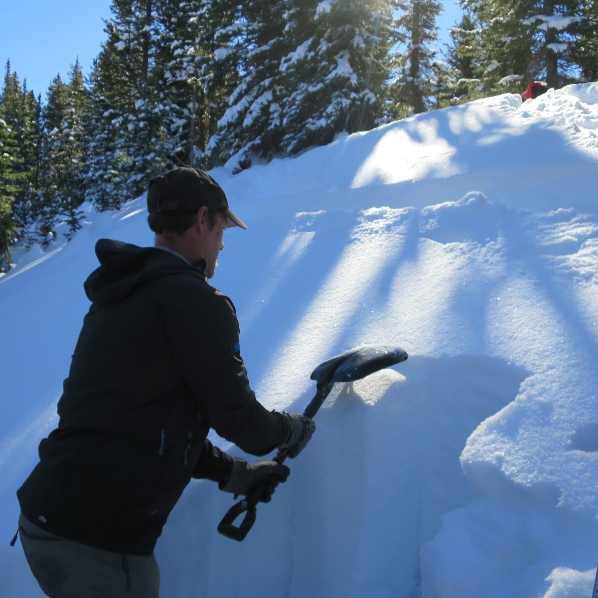
Ed Grote has lived in Moab for 16 years, and in all of that time, he’s never seen the kind of snowstorm that pummeled the higher elevations of the La Sal Mountains just before Veterans Day.
“We’re a month to six weeks ahead of anything we’ve had since I’ve been here,” the Utah Avalanche Center volunteer said. “It’s just amazing how much snow we have.”
Thanks in large part to that storm, there’s currently about three feet of snow in the higher elevations of the La Sals, according to Utah Avalanche Center forecaster Eric Trenbeath.
“It was the biggest storm in the region – more snow than Colorado; more snow than northern Utah,” Trenbeath said.
Although obstacles like stumps, rocks and deadfall are hidden below the surface in some areas, Grote said the local backcountry ski season is still off to a strong start.
“I don’t remember skiing before Thanksgiving, and I certainly don’t remember skiing two weeks before Thanksgiving, which is what some people did,” he said.
By the time that Grote ventured up into the North Woods area on Saturday, Nov. 21, he found that many other people were also ready to enjoy the early-season skiing and snowmobiling.
About 25 cars had filled the Geyser Pass parking lot when he returned in mid-afternoon, although he saw just three other people in the backcountry, including two cross-country skiers from Salt Lake City.
“They said we had more snow than they did, which is why they came down,” he said.
However, as more time passes between major storm events, Trenbeath reports that the snow surface is becoming tired and worn, due to the effects of wind, sunshine and warmer temperatures.
So far this season, Trenbeath has already documented naturally occurring avalanches in Gold Basin, where one ran up to 200 feet wide and on for more than 1,000 feet.
Trenbeath, who just began his third year as the forecaster for the collaborative effort between the U.S. Forest Service and the Friends of the Utah Avalanche Center, encourages recreationists to check out the center’s latest forecasts at utahavalanchecenter.org/advisory/moab before they head up into the La Sals this season.
The information they find there can help them avoid the likelihood of triggering an avalanche. More than nine times out of ten, he said, avalanche victims will set off an avalanche themselves, or else someone else in their group will do so.
“It’s not just a random act or unluckiness that causes you to get stuck in an avalanche,” he said.
It might seem counterintuitive, but according to Trenbeath, most avalanches occur when the danger is rated moderate or considerable – not when conditions are more extreme.
“When it’s high or extreme, the weather conditions are usually so violent that you don’t want to be out there anyway,” he said. “It’s typically on a sunny powder day when everything looks OK, but the underlying snow structure is weak, and the weight of a rider or skier triggers it.”
Conditions in the La Sals are not always dangerous, but they’re also not always safe – especially as snow builds up in layers over the course of the season.
“It’s kind of hanging in a state of suspension, waiting for a trigger from an unsuspecting backcountry traveler,” he said.
Weather forecasters have projected that the El Niño weather pattern will hit southern California and parts of the Southwest with record amounts of precipitation this season. If the system reaches this far north, the good news is that the additional snow could help reduce the avalanche danger in the La Sals.
“Contrary to popular belief, a lot of precipitation can ultimately create a more stable snowpack,” Trenbeath said. “The deeper the snowpack, the stronger the underlying snowpack … It’s really periods of high pressure – cold, clear nights – that cause weak layers to form.”
Learning to recognize avalanche terrain is key, he said.
The danger is greatest on slopes that are sharper than 35 degrees – or roughly as steep as an expert-level run at a downhill ski area.
Right now, recreationists face an isolated and moderate danger of triggering persistent slabs on those slopes with a northwest-north-east aspect. The danger is most likely to occur in areas of rocky and more radical terrain, where stiff slabs of snow overlie weak layers below.
In more level areas, recreationists can find groomed trails around Geyser Pass, which are maintained by Lower Utah Nordic Alliance (LUNA) volunteers; San Juan County crews plow the road up to the parking lot.
However, as Grote discovered last weekend, the trailhead is an increasingly popular spot among different user groups, so Trenbeath advises visitors to disperse beyond the area.
“We would like to encourage people to explore other parts of the range,” he said. “The Geyser Pass Trailhead is getting pretty congested, and there’s great snowmobiling opportunities at La Sal Pass.”
According to Trenbeath, the La Sal Pass area features better terrain for motorized recreation.
“There are lots of open meadows, rolling terrain and hill-climbing skills for all abilities,” he said.
However, some of those hills are avalanche-prone, so users need to be aware of the current danger before they go, he said.
Although Gold Basin is closed to motorized recreation, the rest of the mountain range is wide open.
“There’s lots of other great places to go,” he said.
If recreationists are looking for some place that’s more remote, Grote recommends Abajo Mountains near Monticello.
“It seems like it’s far, but it’s only another 15 minutes down the highway,” he said.
Recreationists encouraged to check out avalanche center advisories
It’s not just a random act or unluckiness that causes you to get stuck in an avalanche.
For more information about current conditions in the La Sals, and to find out about upcoming avalanche awareness classes, go to: utahavalanchecenter.org/advisory/moab.