Some information may be outdated.
“One of the most dangerous parts of a Cataract Canyon river trip, in our eyes, is the take-out at North Wash,” said Peter Lefebvre, a commercial raft guide on the Colorado River since 2012. “You run Class III-IV rapids, but then you’re the most scared during the whole trip at the end.”

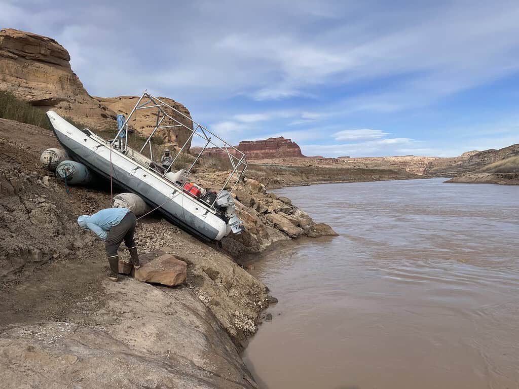
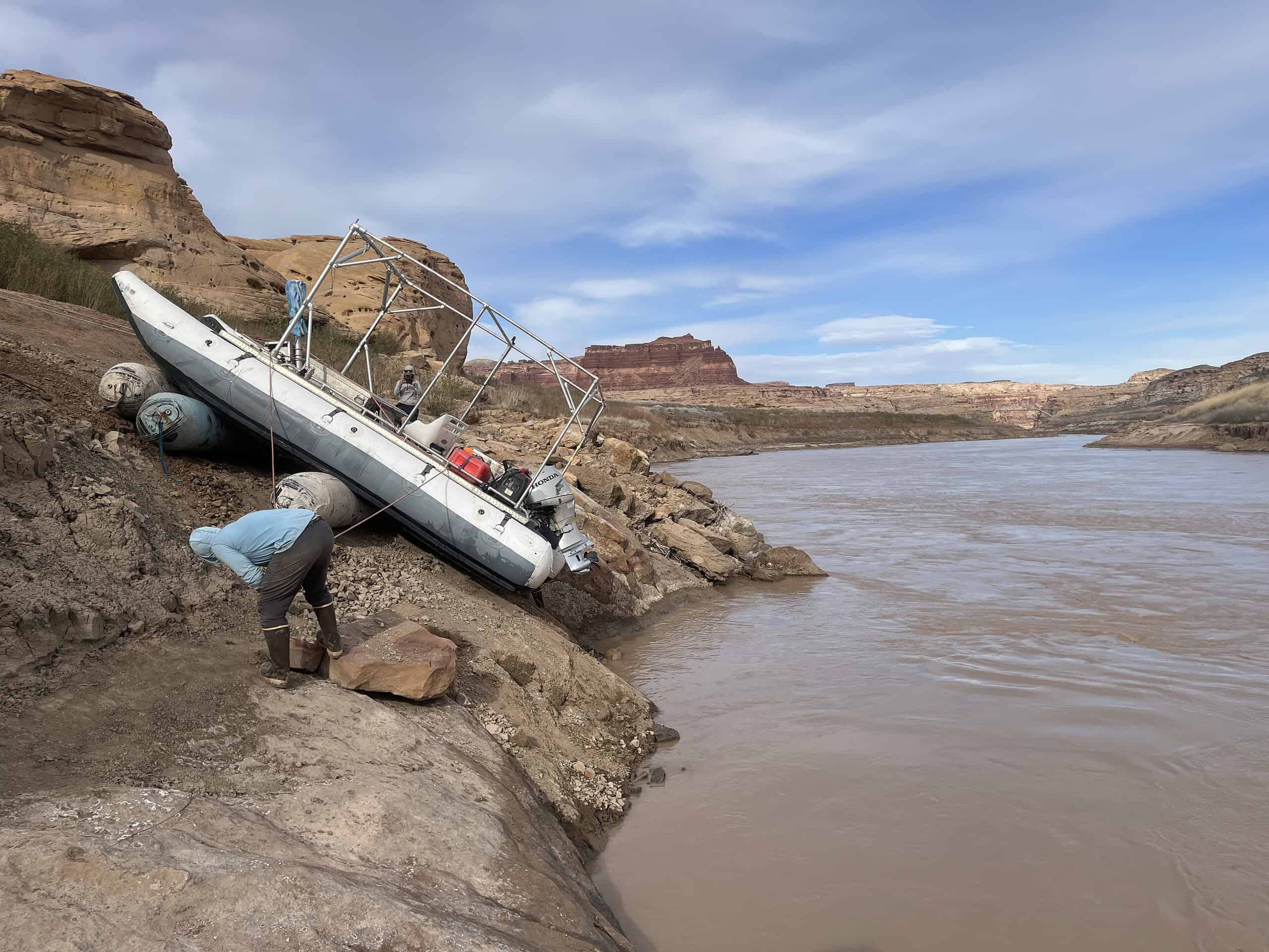
The North Wash Boat Ramp is a take-out critical to access Cataract Canyon, a 48-mile whitewater river trip. In the Moab area, the river section is known as the crown jewel for guides and brings in an estimated five million dollars in revenue annually. However, steep mud banks from sediment erosion are causing the largest obstacle to be on land, not water.
Many guides, including Lefebvre, have seen significant change at the North Wash Boat Ramp in the last three years.
“The situation has been getting worse and worse,” he said, noting that the bank measured at a 56-degree angle before topping out. Lefebvre is also a researcher with the nonprofit Returning Rapids, which documents changes in the Colorado River as the water level in Lake Powell drops.
The fluctuations of river levels and Lake Powell lead to an ever-changing sediment landscape. Commercial guides and private boaters have had to rig complicated rope-hauling systems to get their boats out of the river at the takeout.
Because these deteriorating conditions are a risk to heavy equipment, Glen Canyon National Recreation Area announced a halt on any maintenance at the North Wash Boat Ramp, located on the Hite Marina, on February 3, 2023.
“For the past several years, attempts have been made to modify the North Wash Ramp to ensure that the river rafting community had an accessible take-out location at Hite,” said Mary Plumb, GLCA Public Information Office. She noted that hydrologists and engineers have assessed the area’s sustainability since 2019.
“Conditions today reveal that the ramp is laterally fracturing away from the upper road,” Plumb said. “The silt conditions, coupled with the unstable fractures, prevent heavy equipment work on the unstable, steep, fracturing slope side, making any modification infeasible.”
In 2023, GLCA received $166 million in Disaster Supplemental funds from the Federal Emergency Management Agency to begin addressing low-water infrastructure projects. This includes creating a new take-out ramp.
The site for a new take-out will be a few miles south of the current location on river left, near the Hite Bridge. There is no estimated start or completion date of the project but Plumb stated the construction contract will go out to bid in 2024.
Plumb added there is also the potential to stop all boating access at Noth Wash due to safety hazards.
“At this time we do not see a feasible area to make a public trail on that very steep unstable slope…We have committed to making one more trip this spring to see if anything has changed that may make pedestrian access feasible,” Plumb said. “We are doubtful that anything can be done at this informal take-out.”
Until the new ramp is complete, GLCA recommends traveling an additional 50 miles of flatwater to Bullfrog North Ramp or Halls Crossing Marina, the next take-outs.
Nonprofits Returning Rapids and American Whitewater and local rafting outfitters are encouraging GLCA to look for creative solutions to maintain the take-out until the new ramp is built. For outfitters, the increased mileage adds an additional day of travel, increasing the trip’s cost due to food, gas, and guide’s pay.
“What was surprising, but not totally shocking, was that we didn’t hear a plan for what river runners in Cataract Canyon could expect from now until the new ramp is complete,” said Hattie Johnson, American Whitewater Southern Rockies stewardship director.
Mike DeHoff, principal investigator with Returning Rapids, feels similarly.
“The current site could be maintained to be a primitive access point between now and when a better long-term solution becomes operational,” he said.
DeHoff strongly believes a solution needs to be in place done for the 2024 Cataract Canyon season to ensure access to the area. He suggested regular maintenance of the slope angle, surface durability of the ramp, and sloughing off settled sediments.
North Wash Boat Ramp: A 20-year temporary solution
Running Cataract Canyon is a cross-jurisdictional event.
At the end of Potash Road users begin their trip at Mineral Bottom put-in, operated by the Bureau of Land Management. Canyonlands National Park then manages the permits and the river until the bottom of the rapid known as Big Drop Three. The area below, including North Wash Boat Ramp, is managed by GLCA.
While there are now additional rapids after Big Drop Three, the jurisdiction line was drawn when the reservoir was at full capacity. At lower water levels, rapids that disappeared at high water can reappear.
Paul Grams, United States Geological Survey Hydrologist, explained the current steep river banks at the take-out are connected to the dropping Lake Powell levels.
“When the lake was high, [the sediment] was all inundated by Lake Powell,” Grams said. “When the lake levels dropped, the river cut back through all that sediment that had been deposited earlier. Those are the huge banks in that reach.”
Before the drought of 2002-2003, Lake Powell maintained a water level of 3,670-3,700 feet above sea level. The reservoir reached the concrete ramp at the Hite Marina.
Due to receding water levels in 2003, the Hite Marina could no longer be used with the new average reservoir water level of around 3,600 feet. To alleviate this issue, GLCA created the North Wash Boat Ramp as a temporary low-water access point on river right, half a mile below the confluence of the Dirty Devil River and Colorado River.
The lake levels did not recover to reach the Hite Marina and North Wash Boat Ramp has been used since.
When Lake Powell shrank, the Colorado River also became displaced. Near the take-out, the river has moved out of its original channel.
“There’s been this question of speculation about whether the river would encounter either bedrock or something that doesn’t erode as easily as the lake sediments,” Grams said, adding that this situation can cause the formation of an un-runnable rapid or a waterfall, such as Paiute Falls on the San Juan River and Pearce Ferry Rapid on the Grand Canyon.
Grams explained that it’s difficult to predict or estimate what North Wash Boat Ramp will look like in the upcoming seasons.
“If we have a bad winter, and Lake Powell drops, I would expect to see more erosion start again,” Grams explained. “But if we have a good winter, and Lake Powell stays relatively high, it could be stable—relatively stable—for the next couple of years.”
Appreciate the coverage? Help keep local news alive.
Chip in to support the Moab Sun News.


