Some information may be outdated.
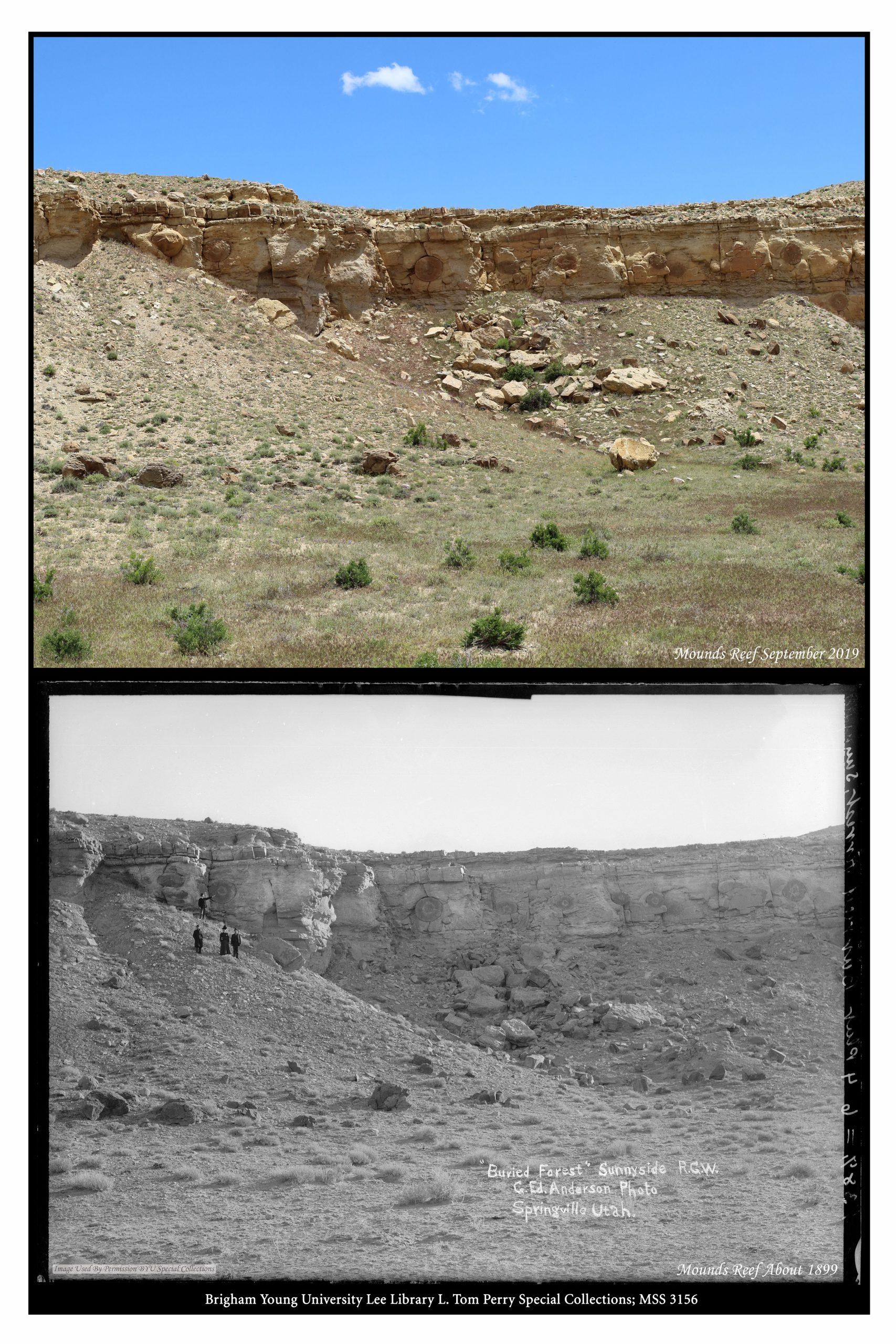
In an old black-and-white photograph labeled “Buried Forest,” four people stand on a hillside under a cliff pointing out unusual round features in the rock face. The features resemble mounted shields or targets, or as suggested by the photograph’s title, fossilized cross-sections of huge trees. When Scott Wheeler of the Carbon County Trails Committee found the photo in an archive last year, he got curious. Eventually, that curiosity led to the development of a new hiking trail.
Finding the ‘Buried Forest’
“I do mapping stuff—I spend a lot of time doing cartography, so I know the area really well,” said Wheeler, but he didn’t recognize the location in the old photograph. It was labeled “Sunnyside,” and Wheeler knew there were no geographic features like that in the present-day town of Sunnyside, which is 25 miles east of Price. He asked friends, museum employees, and local geologists; no one recognized the unusual round features, which are called “concretions” in geology terms. But then Wheeler remembered a bit of local history trivia: an area southeast of Wellington now known as Mounds Reef used to be called Sunnyside. Using GoogleEarth and the help of friends, he was able to locate the spot after about three months of searching.
A gravel road led down to a parking area that was once an oil drill site. From there, a well-trodden game and cattle trail led to a cliff dotted with large, round, embedded concretions that are halved along the face of the rock. Wheeler said there are 15 to 20 such features within 300 yards.
“It’s very unique,” he said of the area.
The circular objects are not fossilized trees, as the old photograph suggests, though the name “Buried Forest” has stuck, modified by the addition of the word “Concretions.” Moab-based geologist Christopher Benson explained that the concretions are thought to form around some kind of organic “nucleus,” such as a fossil or shell.
“This occurs in sedimentary rocks while they are still forming,” Benson said. “Think of a buried layer of sand, immersed in either seawater or groundwater that is subject to a wide range of conditions that could include fluids that have various concentrations of chemicals and/or minerals.”
A mineral, such as calcite, can precipitate out of solution and settle around the organic nucleus.
“This often results in concentric, well-cemented masses that weather more slowly than the softer, surrounding rocks,” said Benson.
Some of the Buried Forest Concretions stretch to several feet in diameter, and often their inner faces are etched with fascinating detail. Sometimes fossils are visible inside.
“There is still much to learn and up for debate about concretions,” Benson said. “One recent study suggests that the process actually occurs quite quickly (geologically speaking) and could help explain why these often preserve fossils.”
Designating the trail
Wheeler and his compatriots agreed the site should be shared and properly stewarded. They contacted the Bureau of Land Management, which owns part of the site, about improving the existing game trail and installing informational and interpretive signs. After the BLM guided an approximately year-long approval process involving Carbon and Emery counties as well as the Utah School and Institutional Trust Lands Administration, all of which govern parts of the area, the trail was approved and the BLM purchased signs displaying the historic and recent photographs of the area, as well as explanations of the concretions. Wheeler and other volunteers from the Carbon County Trail Committee did much of the trail improvement work.
The newly christened Buried Forest Concretions out-and-back trail is about a mile long, and begins about three miles off Highway 6, about 15 minutes from Wellington. Wheeler said there are other interesting sights along the trail, such as fossils of aquatic creatures, remnants of an ancient sea.
A hint from the past
Wheeler’s interest in old photographs began after his mother passed away. She had once lived in Royal, a small community off Highway 6 that is now considered a ghost town, and someone gave Wheeler a historic photograph of the settlement, complete with the date it was taken. He went to Royal on that date and found the place from which the photo was taken, and took some current photos of his own.
“I went up there for several hours, waiting for the shade, to get it just right,” Wheeler remembered.
He later compared the historic photo with the present-day images. When he shared the result with friends, they were fascinated to see some of the same rocks and geologic features, alongside other elements that had changed over time.
“I had such a good time doing it, I started doing the same thing on a whole bunch of other photos,” Wheeler said. He searched archives for high-resolution historic images, often finding candidates in old mining snapshots. He gave presentations on his work to museums and historical societies in Carbon and Emery Counties.
“My history teacher would be rolling over in the grave,” he chuckled, recalling that he had hated history class when he was in school.
One photographer who surfaced frequently in Wheeler’s searches was George Edward Anderson, a Utah native born in 1860 who took thousands of portraits and photographs documenting Utah life. It was Anderson who took the photo, circa 1900, that spurred Wheeler’s hunt for the mysterious concretions. When he finally located the area, he lined up and snapped a photograph of the very same cliff aspect captured in the old black-and-white photo.
Wheeler encourages people to visit the site and spend some time looking closely at the unique geology and paleontology.
“In the afternoon with the sun in the west, those concretions just glow,” he said. “They’re an orange color, and they’re offset… I think they look quite beautiful.”
Carbon County trails group creates a new hiking destination
“In the afternoon with the sun in the west, those concretions just glow.”
– Scott Wheeler
Appreciate the coverage? Help keep local news alive.
Chip in to support the Moab Sun News.


