Some information may be outdated.
The Moab area and its residents are no strangers to changes in land use. From mining to ranching to agriculture to recreation, residents have long been debating the pros and cons of various impacts on the environment. Now, the Moab area will become part of a continent-wide scientific study of those impacts on natural resources and biodiversity.
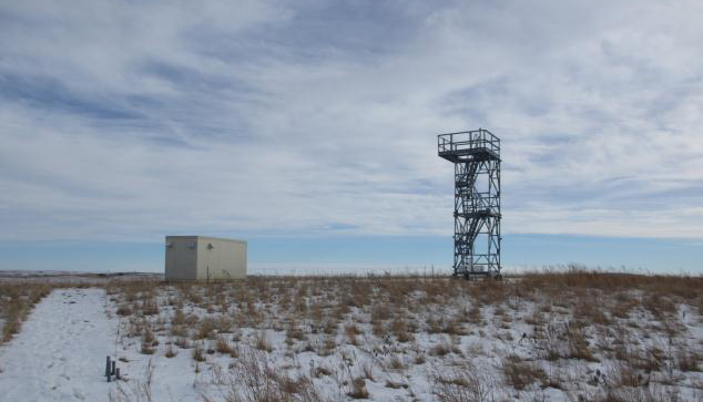
NEON, Inc. a non-profit corporation funded by the National Science Foundation, is creating a large-scale infrastructure for ecological data collection known as the National Ecological Observatory Network (NEON). This network of 106 observatories—or field sites—across the U.S. is designed to take consistent automated measurements of the physical and chemical properties of the soil, water, and atmosphere of an area.
NEON has divided the U.S. including Alaska, Hawaii, and Puerto Rico, into 20 domains. Each domain represents a distinct region of vegetation, landforms, climate, and ecosystem performance. The Moab area is part of a domain that includes the Colorado Plateau and southern Rockies.
The standardized set of data gathered from each field site, combined with human-collected field data on specific animal and plant species, will help people understand and forecast how the causes and effects of ecological change are linked across the continent.
“This isn’t the first time people have studied this issue, it’s just that it’s the first time people have studied this issue on a continental scale,” NEON, Inc. communications manager Jennifer Walton said. “We’ll able to understand change over time on a much larger scale and scope than we’ve ever been able to before.”
NEON’s Moab field site, which is actually located near Wilson Arch on land managed by the Moab BLM field office, is linked to a series of other sites that move over the Rocky Mountains and into the Great Plains.
“There are different regional issues that scientists are looking at,” Walton said. “The reason we chose the Moab location, that site is linked to a series of other sites that essentially follow a line where we’re looking at dust deposition.”
The idea is to have a network on a gradient, U.S. Geological Survey research ecologist Jayne Belnap said.
“That gives us some idea of dust production at lower elevations, and then two stations at higher elevations to look at dust deposition. And then on other side of the Rockies, have a gradient rising up from urban areas.”
Scientists can then look at everything from dust to nitrogen that is deposited on top of the mountains, and the impacts that follow.
According to information on the National Science Foundation’s Web site, dust stirred up in the desert blows over the mountains and gets deposited on the snowpack, making the snow darker in color, which makes it absorb more sunlight, which makes it melt more easily, impacting river runoff.
Dust can cause mountain snow pack to melt 30 or more days earlier than indicated by historical records, according information from the NSF and National Weather Association. The early and accelerated meltdown can lead to flooding in the spring and also contribute to drier soil in the summer.
Though no agency is specifically studying dust-on-snow in the La Sal Mountains, “it’s there,” Belnap said.
Changes in the soil moisture content are evident locally, affecting farming and landscaping, Utah State University extension agent Michael Johnson said.
“People come to me wanting to know how to manage these changes in landscapes and farms,” he said.
“You get melting snowpack that could lead to either flooding or drought, which will have an impact on agriculture and potentially something like the skiing industry,” Walton said. “All of that information we’re collecting about how dust is traveling over the Rockies can help inform how decisions are made, particularly in this local area but also broader than that.”
The Moab field site is one of NEON, Inc.’s 40 relocatable land sites, and will be moved every 5-to-10 years to a new location within the same domain.
“The reason for that is we want to make sure we’re getting an accurate snapshot of the whole domain,” Walton said. “The National Science Foundation is still working with NEON community members to work out what the criteria for the new location will be.”
The regional office and staff used to manage the Moab field site and other sites within its same domain will most likely be located closer to the domain’s core—or permanent—site, which is in northern Colorado, Walton said.
Sites go through multiple phases before they are complete and the Moab site is in the beginning phase of construction.
“We estimate that civil construction, the first phase, will take approximately three months – so folks will be able to see the bare bones of a site by approximately early May,” Walton said. “From beginning to end of all of the phases, we estimate approximately a year before full data is flowing.”
The NEON system and its resulting data is meant to be an open resource for the public., according to the NEON, Inc. Web site.
“Over time, we look forward to providing many different types of data, infrastructure, models, and education programs to engage anyone who wants to learn about and use ecological data,” according to the Web site.
All data collected is available through NEON’S data portal at data.neoninc.org. As sites are completed, more data will be flow into its portal.
According to the Web site, the construction phase of the entire network, which began in spring 2012, will take approximately five years. NEON expects to be in full operation by approximately 2017 and will collect data for 30 years.
Moab outpost will join national network in gathering atmospheric data
“This isn’t the first time people have studied this issue, it’s just that it’s the first time people have studied this issue on a continental scale. We’ll able to understand change over time on a much larger scale and scope than we’ve ever been able to before.”
Appreciate the coverage? Help keep local news alive.
Chip in to support the Moab Sun News.


