Some information may be outdated.
Since last week, the Pack Creek Fire in the La Sal Mountains has grown from 8,518 acres to 8,952 acres. Fire officials reported that the fire is now 66% contained as of June 23, meaning that percentage of the perimeter is hemmed in by secure fireline.
“Crews continue patrolling the fire perimeter in Pack Creek and are working to ensure that no hotspots spread past containment lines,” an update from the multi-agency fire management team said.
Since making a 4,500 acre gain on June 10, the wildfire has not made a significant burst of growth in spite of dry fuels, occasional bouts of high winds and ongoing high temperatures. Increased relative humidity levels compared to those observed during the first days of the fire have helped crews in their containment efforts.
When conditions allow, firefighters are using fire as a tool: on June 17, when temperatures were cooler, the sky was overcast, and winds were in a favorable direction, crews burned fuels in a controlled way to create a fireline, starting on the south side of Mount Mellenthin and moving north.
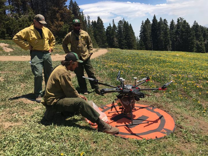
Another tool fire managers have begun using in recent years are unmanned aircraft systems, or drones, equipped with infrared technology. This tool can quickly gather detailed information on hotspots and terrain, while minimizing risk to personnel. Two crews on the Pack Creek Fire have specialized training in the use of these aircraft.
As part of efforts to make roads safe for travel, crews have been removing hazardous trees (those that are weakened and could fall), as well as downed trees, from areas in and along roadways. A piece of equipment called a masticator, which grinds up vegetation, is being used along the Warner Lake Road to open up the thickly vegetated corridor and widen the fuel break offered by the road.
Fire officials warn that inside the fire’s perimeter, there are still islands of unburned fuel which could ignite and produce smoke throughout the coming weeks. Smoke observed from the fire area is not necessarily an indicator that the fire perimeter is expanding, but could be produced by a firing operation being conducted by crews, or by green fuels within the containment line catching fire.
Officials have opened the La Sal Loop Road to travel, but recommend that motorists avoid the road unless needed to access private property. The road is still being heavily used by the nearly 400 personnel assigned to the fire. The Oowah Lake, Geyser Pass, La Sal Pass and Dark Canyon Lake roads are still closed, and most of the La Sals are closed to recreation. Evacuation orders remain in place for areas east of Geyser Pass, including Blue Lake and Dark Canyon.
Meanwhile, other wildfires in the area have ignited, including the lightning-sparked Sego Fire in an extremely remote area in the Book Cliffs, north of Thompson Springs.
Fire officials say that resources and personnel from the Pack Creek Fire will assist with other area fires in an attempt to prevent another blaze from growing large.
For up-to-date details on all fires in Utah, visit www.utahfireinfo.gov.
Appreciate the coverage? Help keep local news alive.
Chip in to support the Moab Sun News.


