
Fire spreads north and east as 451 personnel battle blaze across Utah-Colorado border
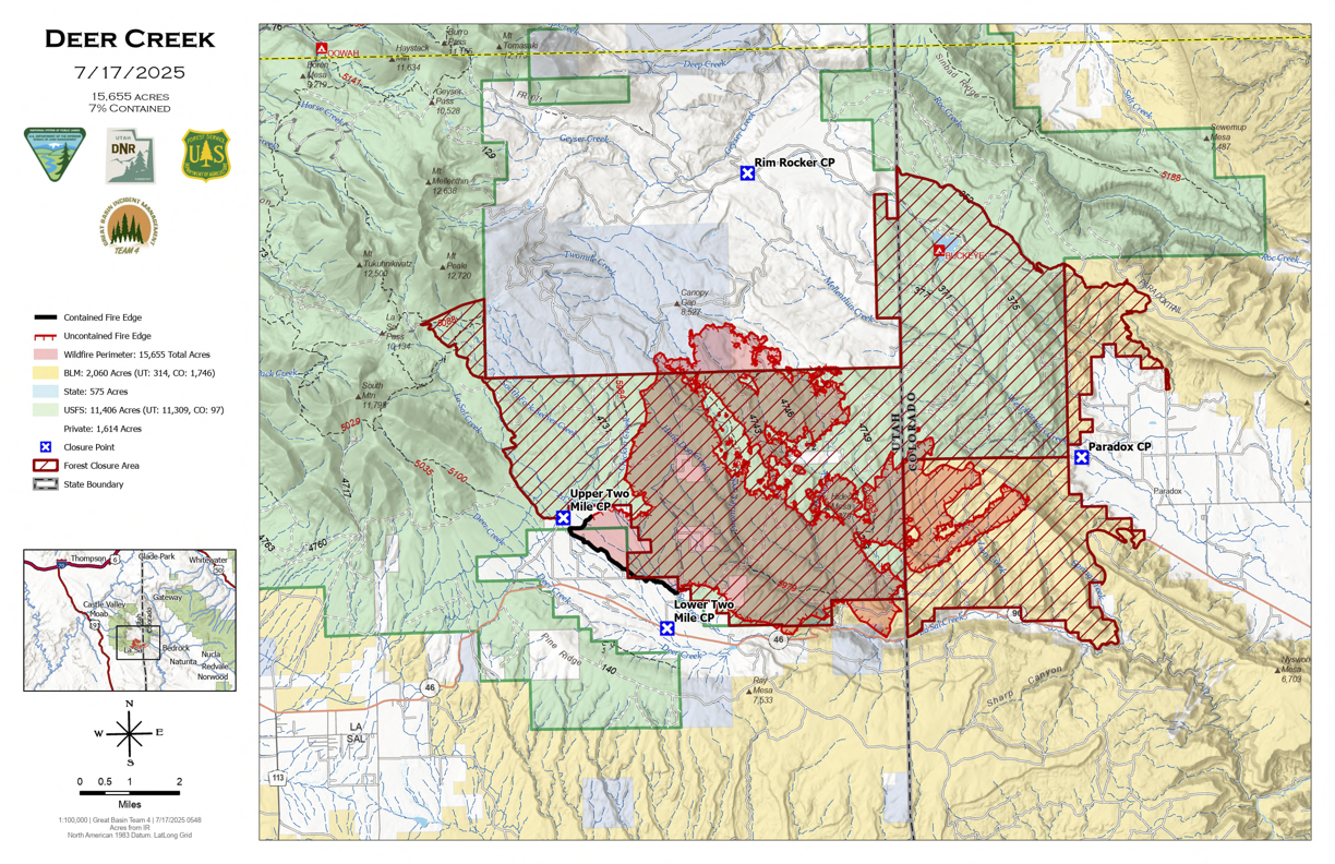
The Deer Creek Fire has grown to 15,655 acres and remains 7% contained as firefighters continue battling the blaze that started July 10 near La Sal. The fire remains active on the north and east sides, with 451 personnel deployed including 6 helicopters, 24 engines, 10 crews, and 5 dozers.
The fire has crossed into Colorado, burning approximately two miles north of State Highway 90 in Montrose County. Rugged terrain and lack of road access have made it difficult for ground crews to reach the north and east portions of the fire perimeter.
Join 1,000+ locals staying informed during wildfire season.
“The fire is burning through aspen stands with a mixture of live standing and dead and down trees,” incident commanders said. “Due to the dryness of the dead trees and their density, the fire is consuming the dead fuels but not rapidly spreading through the aspen stands.”
Today’s forecast includes increased cloud cover and a chance of light rain.
“While rainfall will not fully extinguish the heat on a fire of this size, it will help moderate fire behavior and give firefighters a better opportunity to make progress on containment,” officials said.
Evacuation orders remain in place for San Juan County residents north of Highway 46, between Upper 2 Mile Road and the Utah-Colorado state line. There are currently no evacuations in Paradox, Colorado.
The fire gained international attention over the weekend when it produced a rare fire vortex, commonly called a “firenado.” The phenomenon, which damaged a fire truck but caused no injuries, was rated as an EF-2 by the National Weather Service.
Weather conditions offered some relief yesterday as forecasted wind gusts of up to 60 mph did not materialize. The highest recorded gusts reached approximately 35 mph. A small amount of precipitation fell but wasn’t measurable.
Firefighters are focusing on structure protection around Canopy Springs and Peaceful Valley Ranch residences, using hoses and sprinkler systems. An initial attack group remains staged near the Highway 46/90 junction, ready to respond to new fire starts.
The fire has burned across multiple jurisdictions: 10,563 acres on Manti La Sal National Forest land, 1,491 acres on private property, 536 acres on state land, 314 acres on Utah Bureau of Land Management property, and 2 acres on Colorado BLM land.
The fire’s cause remains under investigation. Officials have stated it was human-caused, and law enforcement and investigators continue processing the scene and gathering witness information.
Road closures
The Manti-La Sal National Forest has enacted an area closure, and county roads within the San Juan County evacuation area are closed to public traffic. The Bureau of Land Management has issued a Temporary Emergency Closure affecting roads in the Paradox area of Montrose County, Colorado.
Emergency alert registration is available through San Juan County at sanjuancountyut.gov/emergency-management/page/san-juan-alerts and Montrose County at montrosecountysheriffsoffice.com/montrose-alerts.
Contact the Deer Creek Fire Information line at 385-393-0516 or email 2025.DeerCreek@firenet.gov for current information. Updated information is available at inciweb.wildfire.gov/incident-information/utmlf-deer-creek and facebook.com/UtahWildfire.
Fire conditions change rapidly. Residents should monitor official sources for the most current information.
Appreciate the coverage? Help keep local news alive.
Chip in to support the Moab Sun News.