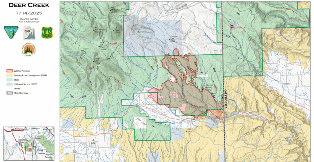
A rapidly spreading Utah wildfire has now grown to over 10,000 acres as the massive Deer Creek Fire races toward the Colorado border with zero containment, forcing hundreds of residents to evacuate their homes.
The San Juan County Sheriff’s Office has ordered all residents north of Highway 46, between the intersection of Upper 2 Mile Road and Highway 46 and the Utah-Colorado state line to evacuate immediately. Highway 46 remains completely closed, with heavy firefighting equipment traveling the route particularly in mornings and evenings.
Fire Explodes to Over 10,000 Acres
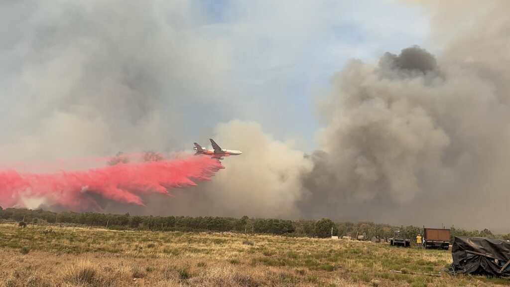
As of Monday morning, July 14, the Deer Creek Fire has grown to 10,058 acres – more than doubling from weekend estimates. The fire remains at 0% containment despite massive firefighting efforts involving 300 personnel, 5 helicopters, 15 engines, 5 crews, and 4 dozers.
Great Basin Complex Incident Management Team #4 took command of operations and reports that firefighters regrouped on Sunday and made progress on the northeast part of the fire that pushed north during Saturday’s erratic wind event. Personnel scouted the Upper 2 Mile Road area and found a strategic location to construct dozer line to protect property and limit additional fire growth near Hang Dog Creek.
The wildfire has destroyed multiple structures in the Mountain Shadow area, with specific damage assessments still being conducted. Local power infrastructure has been damaged, and the fire continues to threaten the Utah-Colorado border region.
Fire Tornado Creates Dramatic Destruction
Saturday, July 12, a fire vortex (commonly called a “firenado”) formed over the Deer Creek Fire, creating one of the most dramatic wildfire phenomena on record.
The pyrovortex caused additional structure damage in the area, though no injuries were reported during this uncommon weather phenomenon.
How This Wildfire Started and Spread
The Deer Creek Fire started Thursday, July 10, about 18 miles south of Moab near the community of La Sal on private property. The cause remains under investigation. Within hours, it grew to several hundred acres before encompassing about 4,000 acres that night. Since initial attack, crews have been focusing on protecting life and property, with structure protection remaining the top priority.
Firefighters Make Progress Despite Challenging Conditions
“Yesterday’s more typical weather and milder winds, and a boost in firefighting resources provided an opportunity to strengthen firelines and begin extinguishing pockets of heat on the southwestern portion of the fire,” according to the official Monday update from Great Basin Incident Management Team #4.
Burning operations were successfully used to remove vegetation remaining between 2 Mile Road and the burned area. Around 125 community members attended Sunday night’s informational meeting at the La Sal Community Center.
Weather Forecast Offers Hope for This Week
Today’s forecast includes the possibility of gusty winds early in the day and a slight chance of thunderstorms Tuesday through Thursday. Critically, Deer Creek’s incident meteorologist noted that this coming Friday and Saturday (July 18-19) offer some of the first chances of meaningful rainfall since the fire began.
This potential precipitation could be the breakthrough firefighters need to gain containment on the massive blaze. Even small amounts of rain could significantly help suppression efforts.
Current Evacuation Orders and Safety Information
All residents north of Highway 46, between the intersection of Upper 2 Mile Road and Highway 46 and the Utah-Colorado state line are under evacuation orders. If you have not already done so, sign up for emergency alerts through the county by visiting San Juan County Emergency Management or Grand County Alert System.
Evacuees can find emergency shelter and information at the La Sal Community Center, located on Highway 46 in La Sal (approximately 25 miles southeast of Moab). The American Red Cross of Utah has emergency shelter supplies and disaster volunteers on standby.
For those who may need to evacuate quickly, officials recommend packing:
– Important documents (ID, insurance papers, medications)
– Essential clothing for 3-5 days
– Pet carriers and animal food
– Cell phone chargers and emergency supplies
Residents in evacuation zones should not return to retrieve belongings once they leave, as wildfire conditions can change rapidly and roads may close without warning.
Join 1,000+ locals staying informed during wildfire season.
Important Things for Residents to Know
Road Closures and Travel Safety
Heavy equipment and firefighting resources will be traveling Highway 46, particularly in the mornings and evenings. Please turn on your headlights and travel with caution through the vicinity.
For the safety of firefighters and the public, the Manti-La Sal National Forest has enacted an area closure. If you have plans to visit the area, please see the closure map before heading out. County roads within the San Juan County evacuation area are closed to public traffic.
Old Spanish Trail Arena Closed
The Old Spanish Trail is currently acting as the fire incident command post for the active wildfires in the surrounding area. Access to the arena property is restricted to essential personnel. The outdoor arenas are open for reserved training and activities. Contact the arena main office at 435-259-6226 to schedule and ask questions.
Stalls and Pens are open for evacuees with livestock, drop in and reservation overnight boarders with livestock.
Air Quality Concerns
Current air quality readings for the Moab area show unhealthy levels due to smoke drift from the Deer Creek Fire. Residents should:
– Limit outdoor activities, especially for children and those with respiratory conditions
– Keep windows closed and use air conditioning on recirculate setting
– Consider postponing outdoor recreation until conditions improve
– Check current air quality at https://air.utah.gov/ before planning activities
What Happens Next
Current projections suggest containment efforts may take significantly longer than initially estimated, with the fire’s explosive growth over the weekend demonstrating its potential. Fire officials warn that evacuations could expand based on fire behavior and weather patterns.
Fire officials emphasize that firefighter and public safety continue to be their top priority as crews work to establish containment lines. The potential for rain this Friday and Saturday offers the first real hope for natural assistance in fighting the blaze.
Live Fire Maps and Emergency Information
For specific current fire information, contact the Deer Creek Fire Information line at 385-393-0516 or email 2025.DeerCreek@firenet.gov.
Official Fire Information Sources:
– InciWeb Incident Page
– Utah Fire Info – Official Updates
– Utah Fire Info Facebook
Local Emergency Information:
– San Juan County Emergency Management
– Utah Emergency Management
– Ready.gov Wildfire Preparedness
Information in this article is current as of Monday afternoon, July 14, 2025, and includes the official morning update from Great Basin Incident Management Team #4. Fire conditions change rapidly. Residents should monitor official sources for the most current wildfire updates.
Appreciate the coverage? Help keep local news alive.
Chip in to support the Moab Sun News.