Some information may be outdated.
The Whole Enchilada mountain biking route is one of Moab’s signature attractions. Officially designated by the Forest Service in 2009, the scenic and challenging trail covers about 30 miles, descending over 7,000 feet from Geyser Pass to the banks of the Colorado River.
The unique beauty of the trail has brought an increasing number of users every year, presenting challenges in how to preserve the trail while welcoming visitors. Forest managers know they need to collect data to make better management decisions for the future.

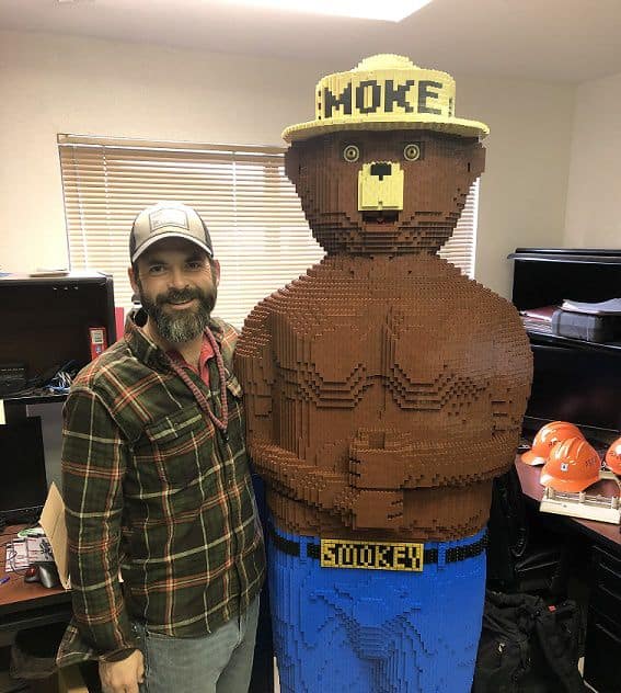
Recreation Specialist Zach Lowe poses with the Forest Service mascot, Smokey the Bear. [courtesy Zach Lowe]
“It’s a really great trail with beautiful terrain, with changing ecosystems from alpine to desert to the Colorado River,” said Zach Lowe.
Lowe is a recreation specialist for the Manti-La Sal National Forest, which contains part of the Whole Enchilada. He recently completed a study that contributes needed data on trail use on the Whole Enchilada while earning a master’s degree in natural resources from the Quinney College of Natural Resources at the Moab Extension of Utah State University.
Lowe has lived in Moab since he was 11, and has worked for the Manti-La Sal National Forest for 7 years. He’s passionate about the beauty of Moab’s outdoors, both sharing it with visitors and protecting it from damage.
“It’s gorgeous and there’s a whole lot of things to do,” Lowe said of the Moab area. “Part of it is also managing the amount of people who come here and also managing what they do. Which is why it fits so well for me to do this capstone project.”
The Capstone project is an “independent project that forms the final requirement for the Master of Natural Resources degree,” explained Melanie Conrad, an academic advisor for the Quinney College of Natural Resources at USU. Lowe’s project served as his graduate thesis; it also provided a needed service to the land management agency.
“It was on a to-do list, we’d been wanting to do that for a long time,” said Brian Murdock, recreation manager for the Manti-La Sal and Lowe’s supervisor, of the carrying capacity study.
Lowe’s project is the first collaboration between USU-Moab and the Manti-La Sal Recreation Department. Murdock thinks the Forest Service partnership with USU could continue to bear fruit in the future, especially once the new USU campus is complete.
“I think the program has a lot of potential to help out the [land management] agencies,” Murdock said. He envisions undergraduates completing internships at land management agencies, helping those agencies complete projects while gaining hands-on experience. “This is the most prime place there is to get an education in public lands. I think it’s an untapped resource,” Murdock said.
Over 30,000 riders a year

Mountain biker riding through an aspen stand on the Whole Enchilada mountain bike trail. [Forest Service photo]
The Whole Enchilada is a technically difficult trail in addition to being long. While the trail is easy to access and a “bucket list” item for many visitors, experienced bikers report that it’s not a light undertaking. But that hasn’t stopped bikers from flocking to the trailheads every spring and fall.
“In the last ten years it has grown in popularity almost exponentially,” Lowe said.
“Everybody’s seen use has kind of exploded around Moab,” agreed Murdock, who has seen visitor trends in Moab change over time.
“Traditionally, it was locals who primarily used the Forest; now people are heading to the mountains,” Murdock said. “We’re definitely getting found out.”
Murdock said Forest Service trail counters installed along the Whole Enchilada trail tick off over 30,000 bikers per year, and that number is increasing by an average of 3,000 new riders every year.
“Last year, we saw the highest use day ever,” said Lowe, who reported that 672 bikers riding from the top of the trail were counted by trail counters in that one day. Lowe added that the trail counters are designed to only pick up bike traffic and are strategically located at “funnel points” where they are likely to catch all traffic.
“I keep expecting it to plateau and some other trail kind of become the ‘cool’ one,” said Murdock. So far that hasn’t happened.
“It’s a badge of honor to ride the Whole Enchilada,” said Murdock. “It’s something people have on their bucket list.”
Making wise management decisions
Forest managers have known for years that they will need to address increasing use on the Whole Enchilada, but they have limited resources to conduct studies. As a first step, in 2013 the Forest Service imposed a moratorium on new permits for shuttle companies bringing clients to the Whole Enchilada.
“People would call and ask [for commercial permits], and it was a hard ‘no’ until we could do what we call a ‘social carrying capacity’ assessment,” Lowe said. That kind of study, he explained, seeks to determine “how many users can we put on the trail in a sustainable manner without affecting the user experience and the resource?”
It takes a mountain biker
A social carrying capacity study can be tricky, Murdock noted, because it’s an assessment of users’ perceptions, which are difficult to measure and compare.
“It is hard,” Murdock said. “It’s not like you’re measuring the amount of soil that’s displaced. It’s a wide variety of opinions when you’re asking people what their experience is like.”
Firsthand personal experience can help study conductors tailor their questions and interpret the results.
“I’m not just a land manager, I also use these lands,” Lowe said. “I’m writing my thesis about a mountain biking trail, so it helps that I’m a mountain biker.”
Lowe designed a 20-question survey and administered it in the fall of 2019, soliciting responses on-site, online or via mailed-in forms. 590 trail users completed the survey, which asked questions about the respondents’ perceptions of trail conditions and feeling of crowding, how they viewed possible trail management strategies, and their interactions with other trail users.
“I needed to get public perception—what they think the trail conditions are, what [people think] the Forest Service or agency can do, other things like, ‘how would you feel about this kind of system or that system,’” Lowe said.
Lowe said some trail users were suspicious of the survey, fearing the Forest Service was collecting data with the intention of eventually closing the trail. Lowe said that’s not what the Recreation Department wants to do at all.
“The goal is just to basically provide a better recreation experience while also protecting the natural resources,” Lowe said. “I’m just trying to find out what the public wants and what we need to do as natural resource managers where both of those are equally protected.”
“Overall, 50% of the respondents said it felt crowded,” Lowe said, summarizing the survey results. “‘Crowding’ is not a number, it’s an individual perception, it’s how you feel.”
Of the people who reported finding the trail crowded, Lowe said, only half of those also said that the feeling of crowding negatively affected their recreation experience.
“Only a quarter of the people felt there were enough people on the trail that it negatively affected their experience,” said Lowe.
Keeping management plans current is a challenge
The study results will inform the development of a visitor use management plan, which will include carrying capacity thresholds and management strategies to maintain those thresholds. Lowe said it’s too early to release any hard numbers.
Another challenge of large-scale land management is the time it takes to collect and analyze data and implement policy. Yet during that time, the conditions in question may be changing.
The current forest-wide management plan was last updated in 1986; forest staff have been working on updating that plan for years.
At the time that plan was created, “Moab had just suffered a huge depression. Slickrock was up, but that was about it for trails,” Lowe said, yet that document is still the current guidance for managing the lands.
Continual monitoring and responsive management are needed to keep public lands protected and keep them open for public use, he noted.
Moab local earns degree while helping National Forest
“It’s a really great trail with beautiful terrain, with changing ecosystems from alpine to desert to the Colorado River.”
– Zach Lowe
Support independent local journalism: become a Moab Sun News digital subscriber or make a tax-free donation on our frontpage today.
Appreciate the coverage? Help keep local news alive.
Chip in to support the Moab Sun News.


