Some information may be outdated.
Moab has experienced some extreme weather variations the past few weeks as sunny days have been followed by numerous rains and snow that has blanketed the parched landscape. But has the area received enough precipitation recently to reverse the region’s years-long drought?
Climate experts say Moab’s recent precipitation is consistent with the weather in the greater geographical region, and was above normal in the winter.
Dr. Nancy J. Selover is an Arizona State University climatologist who spoke about the status and the impacts of the drought in an “El Niño and Extreme Drought in the Southwest: Update and Outlook” webinar. The webinar is a collaborative effort of the National Oceanic and Atmospheric Administration’s (NOAA) National Integrated Drought Information System (NIDIS), National Weather Service, U.S. Department of Agriculture, state climatologists, universities and other drought experts.
Selover said that since the start of the current water year, most areas of the Southwest have been wetter than the 1981-2010 normal. At the same time, temperatures in most areas have been cooler than normal.
“The Colorado River Basin has made a dramatic shift,” Selover said. “We were at less than 70 percent of average for the end of the 2018 water year, by the end of October. We’ve moved to over 150 percent of average across pretty much the entire Colorado River Basin.”
During this time, short-term drought improvement has been significant, Selover said.
“Particularly in the reduction in extreme exceptional drought in the Four Corners region. Extreme drought, or worse, dropped from 25 percent of the southwest at the beginning of October, to just under 7 percent,” she said.
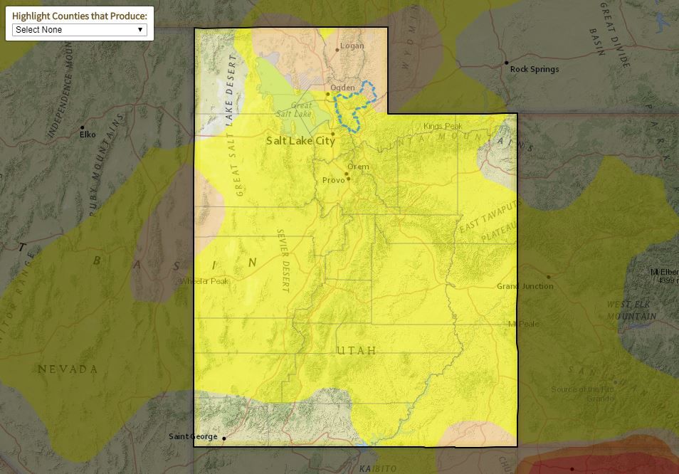
The U.S. Drought Monitor map on March 26 showed 87.5 percent of the state, including all of Grand County, in a yellow-colored rating indicating “abnormally dry” conditions; in 2018, the area progressed on the map into a deep red color to indicate “exceptional drought” conditions, the most severe rating on the map. Near Moab, Ken’s Lake dropped to its lowest level in five years in 2018, with just 25-percent capacity.
Michael Charnick, a meteorologist with the Grand Junction, Colorado, office of the National Weather Service, said it may take some time to fully recharge the soil moisture following the recent storm systems in the region.
“Precipitation in the form of both rain and snow in the Moab region has been above normal this winter season,” Charnick said. “In fact, between Jan. 1 and March 21, Moab has seen 3.85-inches of rain, compared to the average of 1.67-inches.”
A number of variables directly affect the region’s water status, and they also affect each other. Consider soil saturation, for example.
If land by a river is very dry (in other words, the soil has a low saturation of water), then often any rainfall in the area will first be absorbed and immediately locked into the land. The land will retain the water. If later rains or snowmelt further saturate the same area of land, water will begin to seep or runoff into the river or nearby waterways. Only then will the river’s level begin to rise from new ground saturation or water runoff.
Another variable is temperature, and the Moab area recently experienced warm days.
Warmth can sometimes be detrimental to snowpacks. Instead of melting and saturating into the soil, they may simply evaporate.
Soil moisture in the top 1-meter of soil is varied across the region, Selover said. She feels that the current situation is a welcome change, but that “it has not alleviated the long-term water-supply conditions. However, it has made some short-term improvements. Much more is going to be needed in order to improve the long-term situation.”
Selover said the reservoir situation in the region is mixed.
Some reservoirs in Utah and Colorado are starting to see spring runoff but at very low capacities. Others, specifically those along the Colorado River, are full because they are managed.
Lake Mead and Lake Powell are both at about 40 percent, Selover said. The El Vado reservoir in Wyoming began the current water year at about 10 percent capacity.
Lake Powell is currently lower than it was a year ago. New Mexico’s large reservoirs are in much worse condition; the Elephant Butte reservoir in New Mexico is at 7 percent of its capacity.
The ground and bodies of water need more precipitation to return to normal levels.
Some of this recharging in Utah will come from snowpacks, which are near or above average in almost all basins, Selover said, but will need several above-average years of snowpack melt to make up for the deficits.
The ground under these snow packs is dry, which means the land will hoard the water until there is enough to recharge the reservoirs with snowpack melt.
Besides snowpack melt, El Niño rains will contribute somewhat to a springtime recharging.
The El Niño weather pattern in the Pacific Ocean does not occur every year. When it does happen, though, it brings important winter rain and snow to Moab’s dry region.
Mike Halpert, deputy director of the NOAA Climate Prediction Center, explained that weak El Niño conditions are currently present, and that El Niño has about a 55-percent chance of remaining over the northern hemisphere this spring.
Although its anticipated precipitation will be of benefit to the Southwest region, this year’s El Niño will not make a significant impact.
Halpert said the reason has to do with the later-than-usual development of this weather pattern. Typically, an El Niño life cycle starts nine to 12 months before it delivers rains to the northern hemisphere. This extended life cycle gives El Niño the chance to reach its peak strength during the winter, and then it weakens or dissipates during the spring, he said.
This year, Halpert continued, El Niño began its life cycle only recently, in January. It can still surprise us, though, he said.
An El Niño born in March 2015 became one of the strongest El Niños on record.
“The Colorado River Basin has made a dramatic shift.”
Recent precipitation counters persistent regional drought
Appreciate the coverage? Help keep local news alive.
Chip in to support the Moab Sun News.


