Some information may be outdated.
Fidelity Exploration and Development is conducting a 3D geophysical seismic survey on Hatch Point, about 15 miles south of Moab, to determine the area’s potential for oil and gas development.
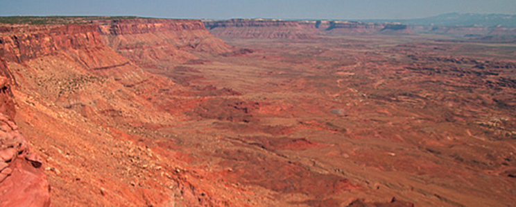
The area to be surveyed comprises 32,186 acres, or approximately 50 square miles, on the northern end of Hatch Point, and is located almost entirely within the Canyon Rims Special Recreation Management Area (CRSRMA). Three scenic viewpoints, as well as Hatch Point Campground, and Trough Springs Canyon Trailhead are located within the project area.
The work started on Aug. 25, and will run through Oct. 15, when it will halt temporarily because of potential disruption to big horn sheep migration patterns. Work will resume on Dec. 15, and run through Jan. 31, 2015.
San Juan County commissioner Phil Lyman said the development would be a boon to San Juan County, bringing better-paying jobs to the area, as well as more funding for schools.
Meanwhile, a host of former national park officials, recreation business operators and environmentalists argue that drilling, especially “below the rim” in Canyonlands Basin, will adversely impact the experience of visitors to both that area, as well as to the adjoining Canyonlands National Park.
“Based on everything I know, I am thrilled about the exploration taking place by Hatch Point,” Lyman said. “If they are successful, I believe it will be a very good thing for San Juan County.”
Fidelity spokesman Tim Rasmussen said that conducting a seismic survey is one of the first steps in oil and gas production.
“The work will provide a map of the subsurface and help us understand those structures and their viability for producing oil and natural gas resources,” Rasmussen said. “After the survey results are analyzed, the next step would be be to drill exploratory wells in the most promising areas.”
Seismic surveys are conducted by creating shock waves (seismic waves), on the surface or below ground, at “source points” along predetermined “source lines.” The seismic waves are created either with explosive charges placed in holes drilled by “shot hole buggies” or helicopters, or by large vehicles known as “thumper” trucks that vibrate the ground.
The seismic waves are reflected by subsurface formations, and then recorded at the surface by receivers called “geophones.” By analyzing the time it takes for seismic waves to reflect and then return to the surface, a geophysicist can map subsurface formations to predict where oil or gas may be located in sufficient quantities to warrant further exploration.
Rasmussen said Fidelity is hopeful that test results will indicate the potential for developing an oil field in the area, but he said that, “it is too early to speculate on any discoveries that may result from an exploratory well in the area.”
Fidelity currently has six wells in operation on Hatch Point, and are in the Environmental Assessment (EA) phase of developing seven more.
According to the Decision Record (DR) from the BLM, the project will require 34 source lines with a total length of about 250 miles. Through the use of thumper trucks, shot hole buggies, and heli-portable drilling, 4,190 source points will be utilized. Total surface disturbance would amount to about 620 acres.
Most of the project area is on a broad mesa west of U.S. Highway 191 south of Moab, and is bounded by Hurrah Pass to the north, Kane Springs Canyon on the east, Lockhart Basin on the west, and the southern portion of Hatch Point to the south. Approximately 4,000 acres extends beyond the rim into Lockhart Basin.
Walt Dabney, Moab resident, and retired superintendent of Canyonlands National Park (CNP), said that he is “very concerned,” about any possible development taking place below the rim in the Canyonlands Basin. While superintendent of CNP, he made a formal objection to the BLM, saying that there shouldn’t be any leases down in the basin because of the, “certainty of compromising the national park qualities of Canyonlands National Park.”
“When you stand on the rim, there is an assumption by anyone who looks into that basin, that they are looking into the park. “What they are really looking at is an illogical, political compromise that resulted in protecting only a portion of the basin. Any development placed in there will significantly diminish the quality of the park.”
Ashley Korenblat, owner of Western Spirit Cycling Adventures said that, “Industrial development of any kind along the the Lockhart Basin Road will seriously degrade a key recreation asset that is used by both the motorized and non-motorized communities and benefits both Grand and San Juan counties.”
“The Lockhart road takes pressure off CNP by providing a back-country experience important to both outfitters and the public,” she said. “Truck traffic and industry of any kind below the rim will greatly diminish the value of the experience and make it difficult if not impossible to sell as a back-country adventure.”
Rasmussen said that though Fidelity is conducting seismic work in Lockhart Basin with the use of helicopters, the company has no plans to drill exploratory wells in the basin at this time.
The project area also has 977 acres of land that have been determined by the BLM to have “wilderness characteristics.” The Southern Utah Wilderness Alliance (SUWA), during the public comment period, proposed that only helicopters be allowed in those areas to reduce impacts to the land.
BLM Moab Field Office manager Beth Ransel acknowledged that there would be temporary impacts to these areas, but said that “after project operations are finished, naturalness would be restored to the wilderness characteristic area.”
In her decision that allowed the project to proceed, she said that, “the increased costs of performing the survey (by helicopter only) … would not correspond to resource protection beyond which is already provided and determined by the BLM to be sufficient.”
SUWA Staff Attorney Neal Clark said that “Any industrial-scale surface disturbing activity has the potential to negatively impact proposed wilderness areas.”
“BLM should be prioritizing the protection of the remaining wilderness-quality landscapes, rather than kowtowing to oil and gas demands,” Clark said. “The only reason Fidelity doesn’t want to use helicopters for the entire seismic project is that it is expensive.”
Rasmussen said that Fidelity is committed to protecting the environment and that they completed an 18-month Environmental Assessment that addressed all environmental issues and mitigation practices including recreation, wildlife, and cultural resources.
“We realize the environmental sensitivity of the areas around San Juan and Grand counties and we work to minimize the footprint of our activities,” he said. “Furthermore, we believe that our activity can co-exist with a vibrant tourism economy, as long as we all understand and respect the concept of multi-use of the lands.”
San Juan County sees potential economic boon from mineral development; Others say any drilling “below the rim” would compromise Canyonlands Basin
We realize the environmental sensitivity of the areas around San Juan and Grand counties and we work to minimize the footprint of our activities. Furthermore, we believe that our activity can co-exist with a vibrant tourism economy as long as we all understand and respect the concept of multi-use of the lands
Appreciate the coverage? Help keep local news alive.
Chip in to support the Moab Sun News.


