Some information may be outdated.
A snow storm dumping more than seven inches of snow in Moab Wednesday, Dec. 4, damaged electrical transmission lines and left highways icy.
The electricity outage affected over 4500 customers, said Maria O’Mara, spokeswoman for Rocky Mountain Power.
“It went out a little after 8 o’clock and was back on within an hour,” O’Mara said.
She said it was directly related to the weather.
Traffic on Highway 191 was closed for about an hour north of Moab Wednesday morning due to accidents involving semi-trailer trucks.
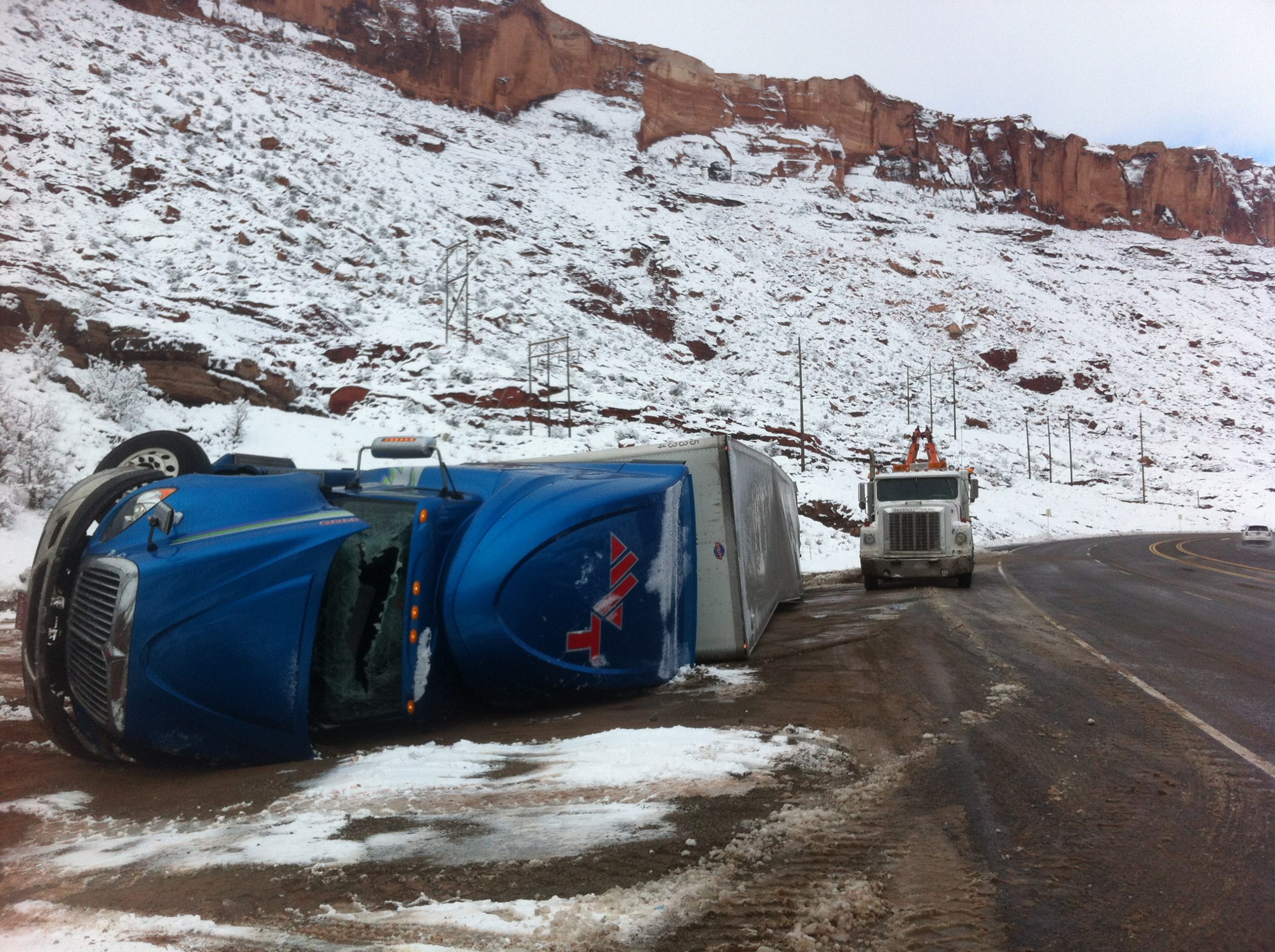
A semi-trailer truck overturned in Moab Canyon north of the Arches National Park entrance.
“He came into that curve too fast and his trailer started to slide,” said Sgt. Richard Haycock with the Utah Highway Patrol. “The trailer flipped him.”
When the semi flipped, the trailer slid and hit the front of northbound Mercedes.
The semi driver was treated and released at the scene by Emergency Medical Services (EMS). The driver in the Mercedes was uninjured.
The semi blocked all four lanes of traffic until it was towed to the side of the road.
Another three semi-trailers hit each other north of the accident within the hour.
“The two accidents together closed traffic for about an hour,” Haycock said.
In addition to the accident, Haycock said that five tractor-trailers slipped off the road and required assistance.
Ron Pierce, who has been measuring weather conditions for the National Weather Service for twenty years, said that the 7.3 inches of snow that dropped on Dec. 4 was a record snowfall for the day. The most snow to fall on that day previously was a half-inch reported in 2001.
Between the storm on Friday, Nov. 22 and the Wednesday, Dec. 4 storm, the Moab area has already received nearly 14 inches of snow. The annual average snowfall for Moab is just under seven inches, said John Kyle from National Oceanic and Atmospheric Association (NOAA).
He also reported that Castle Valley received 11 inches of snow.
Kyle said the snowstorm broke records at other weather stations around Moab as well.
In Canyonlands National Park, the 24-hour snowfall on Dec. 4 was reported to be six inches, which broke the previous record of 1.9 inches in 1983.
Two inches of snow fell in Natural Bridges National Monument on Dec. 4, breaking the record of 1.5 inches set in 1983.
Kyle said that record-breaking cold temperatures followed the storm with one-degree in Moab on Dec. 4, with the previous record of nine degrees set in 1903. In Canyonlands the temperature dropped to negative 3, which broke the previous record of 8 degrees set in 2009.
Erik Trenbeath, the new weather forecaster for the La Sal Avalanche Center, said that 10 to 14 inches of snow with about an inch of moisture dropped during Wednesday’s storm.
Trenbeath was the forecaster between 1999 and 2003. When Max Forgensi ended his time with the avalanche forecast center this year, Trenbeath chose to apply for the position again.
“We’re off to a really good start,” Trenbeath said. “This is one of the better starts I’ve seen since I’ve been here for the last 20 years. We’re doing better than the Wasatch (mountains) at this point.”
On Wednesday, Dec. 4 he said that there was 22 inches of snow at the Geyser Pass trail head and Gold Basin has 39 inches of snow.
“There’s enough snow up there for recreation,” he said, and cautioned skiers, snowmobilers and sledders to still be aware of what may be under the snow, such as trees, stumps and rocks.
During the snowstorm on Saturday, Dec. 7, an additional four to eighteen inches of new snow dropped on the mountains.
“It was extremely variable,” Trenbeath said. “In the general recreation area, it was about eight inches on average of new snow.”
Trenbeath posts advisories after each storm and for the weekend for the La Sal Mountains on the Utah Avalanche Center’s web site. He encourages people to check it out before the go up on the mountain to know what the conditions are.
The snowstorm on Saturday, Dec. 7 dropped an additional three inches in Moab and Castle Valley, Kyle said.
“For the past few weeks, we’ve been in a similar pattern as last winter,” Kyle said. “In valley areas, there isn’t much hope of a warm-up. High pressure, which typically brings warmer temperatures, only sets up a cold inversion, where cold air is trapped in valley areas with warm air above it. The next week doesn’t look remarkable for any winter storms, but no real warm-up in sight either.”
Second snowstorm of the year brought another electricity outage
“He came into that curve too fast and his trailer started to slide. The trailer flipped him.”
http://utahavalanchecenter.org/advisory/moab
Appreciate the coverage? Help keep local news alive.
Chip in to support the Moab Sun News.

