Onlookers stood shoulder to shoulder on the bridge over Pack Creek on Mill Creek Drive on Sunday evening, watching ash-blackened flash flood waters rush below. The creek swelled its banks and quickly picked up speed, bringing an earthy smell of ash and silt and dragging logs and other debris along its widened path before receding.
As of Monday morning, county road crews are cleaning debris from areas affected by the flood, and will assess any damage once they’re cleared. Weather officials say debris flows from the Pack Creek Fire burn scar will be possible throughout the summer, depending on weather events.
Heavy precipitation in the watershed of Pack Creek on Sunday caused the flash flood. A National Weather Service flash flood warning was in effect for the Pack Creek Fire burn scar between 3:30 and 6:30 p.m. that day. Megan Stackhouse of the Grand Junction office of the National Weather Service said radar equipment estimated between 0.80 and 1.20 inches of rain over the western part of the Pack Creek Fire burn scar, much of it falling in a 30-60 minute time period.
“Mud, ash, and other debris from the burn scar will flow into the adjacent creeks in an event such as this,” Stackhouse wrote in an email to the Moab Sun News. “Unfortunately, burn scar flooding is a common occurrence during the summer months across the entire western U.S.”
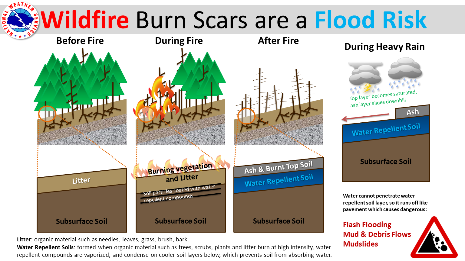
During a fire, burning vegetation and leaf litter coat soil particles with water-repellent compounds, leaving a hydrophobic layer on the ground, she explained.
“Essentially, rainfall is not able to absorb in the burned ground and therefore it runs off quickly, especially when a large amount of rain falls in a short period of time,” she said.
The U.S. Geological Survey does not maintain gauges on Pack Creek, but it does have several gauges on Mill Creek, including one below the confluence of the two waterways. Publicly available data from the gauge below Pack Creek shows that between 6:30 and 8:45 p.m. on Sunday evening, the flow rose from 0.34 cubic feet per second to a peak of 675 cubic feet per second. A height gauge at the same location showed the water level rise from 3.37 feet to 11 feet over the same time period. An average flow for this time of year, based on the last three years of data as reported by USGS, is around 1 cubic foot per second. As of Monday morning, the flow has decreased to just under 5 cubic feet per second at the Mill Creek gauge located below the confluence with Pack Creek.
Photos and videos on social media show residents watching in awe all along the creek Sunday evening as the waters rose up around tree trunks, created new wave patterns, and seeped into low-lying areas in the flood plain. One clip shows a large raft, slathered in wet mud and ash, being carried downstream. One commenter wrote that part of a swingset had been carried away from a back yard.
Mill Creek also showed evidence of high water on Monday. Rocks and tree debris had been moved, and vegetation along the creek banks was flattened. The creek water was opaque, but unlike Pack Creek, the color was reddish-brown, not black.
Glen Arthur, assistant road supervisor for the Grand County Road Department, said Kerby Lane, Old City Park Road, and Shumway Lane were closed starting at about 5:30 p.m. on Sunday evening due to the flood. Work crews arrived at 7 a.m. on Monday to begin clearing mud, tree limbs, and other debris left in the road by the high water.
Arthur said this is the second time since the Pack Creek Fire that the creek has flooded and brought debris onto those same roads; in the previous event, the roads were not damaged. Arthur said they’ll have to wait until the debris is cleared to see if repairs will be needed after Sunday’s flood.
Stackhouse advised that during monsoon season, people should check forecasts and conditions before heading out for the day. https://www.weather.gov/gjt/ gives weather information for the Southeast Utah/Southwest Colorado area, and current road conditions can be found at the Utah Department of Transportation website at https://www.udot.utah.gov/connect/current-conditions.
Stackhouse also said a burn scar like the one left by the Pack Creek Fire leaves the area prone to flooding if weather events line up.
“It all depends on if the heavier showers and thunderstorms set up over the burn scar and dump a large amount of rain in a short amount of time,” she said.


