The Moab City Council and the Grand County Commission held a joint workshop on June 22 just before the regular City Council meeting to hear a presentation from Kara Dohrenwend on the work of the Mill Creek Community Collaborative, a local group of stakeholders who have been discussing management tactics at the increasingly popular recreation areas along Mill Creek.
Dohrenwend is the director of Rim to Rim Restoration, a local nonprofit dedicated to the restoration and conservation of native vegetation, and has been involved in Mill Creek planning and restoration efforts since the 1990s. She spoke to the council and commission on behalf of a group of about 40 people representing 17 agencies and organizations as well as private property owners that have been involved since 2018 in a more formalized stakeholder group, the Mill Creek Community Collaborative. The group has completed a document detailing a set of specific recommendations for new management strategies for the area that address parking, access, trails, signs, and possible fees.
Need for management
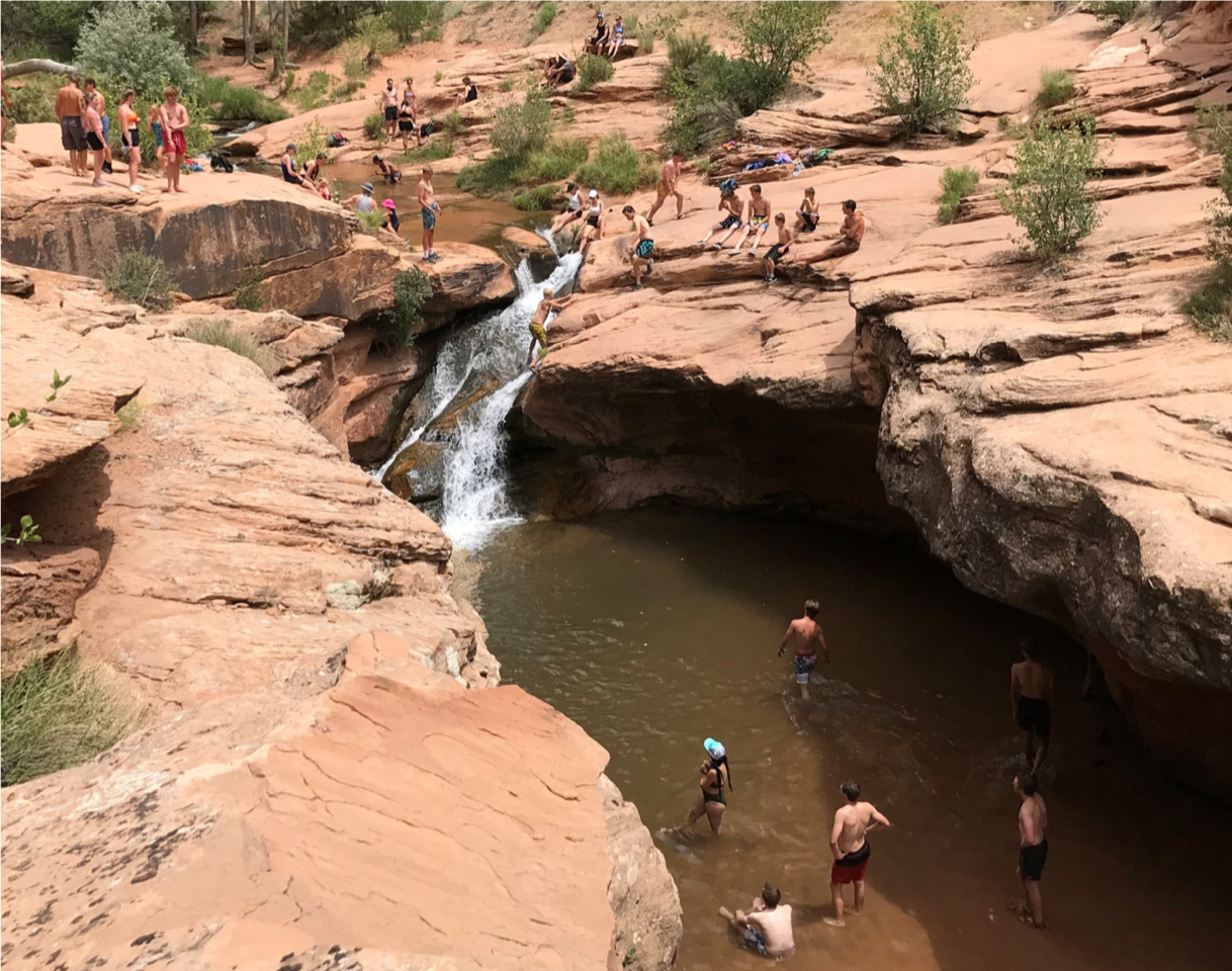
“You all know how things have changed in Moab, you know how many more people are here, how much crowding that’s creating,” Dohrenwend told the meeting participants, displaying photos of crowds of visitors in the Powerdam parking area and the popular waterfall area in the north fork of Mill Creek. Those visitors cause damage to natural resources like plants, biological soil crusts and animal habitat, and more people also leads to increased frequency of search and rescue or emergency medical situations. Teams of emergency responders transporting equipment and sometimes patients can cause even further damage to those natural resources.
Stakeholders observing this increased use have sought to address it for years. In the 1990s, said Dohrenwend, surveys showed that many locals favored a “keep it secret” approach to protecting Mill Creek Canyon. Hotels agreed not to carry literature promoting the canyon, and the BLM agreed not to issue commercial permits for the area or promote it as a recreation site. However, over the past decade, online data hubs and social media have superseded other methods of information sharing and promotion, prompting the need for more active management. Surveys conducted by the MCCC in 2019 and 2020 revealed that more respondents support more active management strategies.
“It’s time to do something different—just ‘not telling anyone’ doesn’t work anymore,” said Dohrenwend, summarizing the prevailing view reported through surveys.
To guide its discussions of how best to manage the beloved area, the MCCC developed a vision statement, defining its mission as to:
“Collaboratively address impacts from increasing recreational use in Mill Creek Canyon by providing access to a quality experience for canyon visitors in a way that protects the natural and cultural resources of Moab’s backyard and addresses impacts to nearby neighborhoods.”
Dohrenwend summed up the purpose of the group by saying, “The real crux of it was a need to really address impacts on the natural world.”
The group also collected input from the community through surveys, looking to gauge what users value most about Mill Creek and what kinds of management strategies they would support.
Complexities and recommendations
The Mill Creek area, Dohrenwend explained, presents complex management challenges in part because it is owned by or abuts property owned by many different agencies and private individuals, including the Utah School and Institutional Trust Lands Administration, the Bureau of Land Management, the City of Moab, and Grand County. Dohrenwend reminded meeting participants that a new subdivision has been approved for the open area along either side of Powerhouse Lane leading up to the Powerdam parking area, which will add more stakeholders as well as further congestion to the already heavily used access point.
The MCCC also identified four distinct use zones along the Mill Creek corridor. The “Urban Creek” zone runs through town, where the city’s Mill Creek Parkway follows the creek, and is heavily used for transportation through town. The MCCC did not address this zone with recommendations, but focused on what it designated the front country, middle country, and backcountry zones in the Powerdam area. The front country encompasses the Powerdam parking area to the waterfall; the middle country refers to the walking trail on the south rim of the canyon popular with locals, close to residential areas; and the backcountry encompasses much of the Right Hand fork of the canyon and Left Hand beyond the waterfall.
Dohrenwend said that for the riparian corridor, which winds through all of the use zones, the group recommends designating a trail system and developing a longterm vegetation management plan.
“Those are the two really critical things that were put forth for the riparian corridor,” she said. Currently, though trails exist in the canyon, they are not officially designated. Creating a designated system would include an environmental assessment in accordance with the National Environmental Policy Act, and would also allow for access to grant funding and coordinated trail maintenance efforts. Designating a trail system was a priority recommendation for all the use areas identified by the MCCC.
For the backcountry zone, the group also recommends increased monitoring efforts to collect data on use and impacts in those areas. In the middle country, the group recommends improved and more consistent signage, development of best management practices for issues like erosion and invasive species, and monitoring visitor use and impacts.
The frontcountry zone is the most complex and most heavily used, Dohrenwend said. BLM traffic counters on the gravel road leading to Powerdam counted over 57,000 cars using the road in 2020. The high use in this zone calls for more drastic management efforts. For this zone, the MCCC recommends obtaining archaeological clearance and designating a trail system, as in other zones; more significant recommendations include establishing a trail from Potato Salad Hill to the dam, possibly building a pedestrian bridge across the creek in the Powerdam area, and possibly shifting the main access from the Powerdam area to the Potato Salad Hill area. Powerhouse Lane could still be open to pedestrians and cyclists, as well as emergency personnel.
Dohrenwend acknowledged the need for enforcement of any new regulations, and also noted that the blend of jurisdictions in the area means that enforcement is also difficult.
The MCCC also suggests that the BLM collect a user fee using an “iron ranger” system at the new Potato Salad Hill parking area, with the option for an annual pass.
The MCCC’s recommendations will have to be further examined to determine which agency would be responsible for each change, and further public process will be needed before any of those changes may be implemented.
The full document with the MCCC’s recommendations, as well as analysis of survey results, can be found on the group’s website, https://moab84532.wixsite.com/mccc/about.


