The Bureau of Land Management Price Field Office is working on a plan to manage the San Rafael Desert and establish official roads and trails where motorized vehicles may travel.
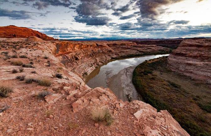
The San Rafael Desert, a large area in Emery County bounded by Interstate 70, state Route 24 and the Green River is popular with off-road and backroad motorized users, as well as with hikers, bikers and other outdoor recreationists.
In a Dec. 16 press release about the plan, the Southern Utah Wilderness Alliance calls the San Rafael Desert “a sublime area of Utah’s backcountry… It features stunning redrock canyons, important cultural sites, and an outstanding diversity of native pollinators (bees and wasps).”
An incomplete map
Currently, management of the San Rafael Desert is guided by the Resource Management Plan that applies to the BLM Price district.
Throughout the 1990s and early 2000s, the Price field office incrementally changed regulations in their district, gradually limiting motorized travel to designated routes. However, not all routes that were in use under previous, looser restrictions were surveyed, leaving a discrepancy between official route maps and what appear to be well-established routes on the ground. The BLM’s Draft Environmental Assessment for the new travel plan acknowledges that discrepancy, and the need for a thorough and accurate plan; its assessment states that the absence of clear policy creates “uncertainty for users on the ground.”
“Additionally, route proliferation has been and continues to be a concern in the area, contributing to increased conflict among various recreationists, habitat fragmentation, and soil erosion,” the environmental assessment states, acknowledging the long history of challenges to off-road routes through rural areas in southern Utah.
A complex history of changing management strategies and pressure from wilderness advocacy groups, particularly the Southern Utah Wilderness Alliance (SUWA), precede the current planning process.
In 2008, SUWA and other conservation groups filed a lawsuit against the BLM with objections to the department’s proposed management plan in Richfield, claiming that that agency had not applied federally required “minimization criteria” when designating off-road routes in the plan. These criteria mandate that off-road vehicle travel must be balanced against potential damage to soils, watersheds, wildlife, air quality and conflict with other users.
The judge ruled against the BLM and the parties reached a settlement in 2017 that requires the BLM to re-examine thirteen management plans in different districts, including the Price field office.
In addition to addressing clarity of rules and protection of natural resources, the Draft Environmental Assessment says the agency also considered how the plan would affect access to non-BLM parcels within the study area, particularly lands owned by Utah’s School and Institutional Trust Lands Administration. It must also address how the plan will provide for recreation experiences and how it may provide for and encourage entrepreneurial activities that align with the other regulations and objectives for the area.
Alternatives
The draft plan outlines four “alternatives,” labeled A through D, of management approaches. Alternative A maintains the status quo—no action is taken to amend the existing travel plan. Alternative B emphasizes resource protection over visitor use. Under Alternative B, only 30% of currently inventoried routes would remain open to OHVs, and 70% would be closed. Alternative C shifts the emphasis toward visitor use, with 65% of the inventoried routes remaining open, and 35% being closed. Alternative D is the least restrictive, allowing for 74% of inventoried routes to remain open and 26% to be closed.
The “status-quo” of Alternative A is a subject of contention among some interested groups.
Clif Koontz is the director of Ride with Respect, a Moab-based non-profit dedicated to preserving trail access for motorized and other user groups, resource protection, and harmony between user groups. Koontz wants the public to be aware that the nominal travel plan is deeply inadequate and does not reflect what the trails actually look like and how they are used.
“The largest misconception is that the current travel plan is a baseline to evaluate the other action alternatives because the current travel plan is completely incomprehensible and indefensible,” Koontz said.
Koontz said the 2008 travel plan outlines road fragments and routes that don’t link to one another, creating a confusing and illogical route system which does not accurately show routes that, in reality, appear to be well-used and sanctioned.
“Most people, when they go out there, they would have no idea that many of these routes—though well established—aren’t technically legal routes to ride on a motorized, or mechanized vehicle right now,” Koontz said.
This summer Ride with Respect submitted a joint letter to the BLM with Sage Riders, a Price-based motorcycle club that has volunteered hours of trail work in the area, and the Blue Ribbon Coalition, a national nonprofit that advocates for responsible recreation. The letter expressed support for Alternative D in the draft plan, which of the proposed alternatives, will close the fewest miles of OHV trails.
“Even though ‘Alternative D’ is the most access-oriented of the four alternatives, it would effectively conserve the other social and natural resources,” the letter says.
“It’s all a question of how many [routes] they’re going to close,” Koontz said. “I would venture to guess that at least some of them should be closed because of excessive resource impacts or being impractical to manage or being basically purposeless in being redundant for recreational and non-recreation uses.”
However, he thinks that people who are unfamiliar with the area can’t make an informed opinion without considering the routes inventoried since 2008.
The Southern Utah Wilderness Alliance is strongly opposed to any plan that would add more official OHV routes to the map in the 2008 Resource Management Plan.
“Off-road vehicles have a really large impact on public lands,” said Laura Peterson, staff attorney at SUWA. “Certainly we’re not trying to outlaw the use of off-road vehicles on public lands. What we’d like to see is some really forward-thinking planning that goes around it, saying ‘Let’s designate trails that make sense, let’s make sure people have access to recreation to off-road opportunities, to scenic overlooks’—but not at the expense of all other uses of that land, not at the expense of soils, of watersheds, of cultural resources.”
Peterson said SUWA staff have been studying the area closely for a long time, especially as it has been involved in litigation brought by SUWA over the past decade. She said many of the routes inventoried by the BLM since the 2008 plan are actually, on the ground, not routes at all–they may be old seismic lines, or just open desert.
“One of the things that we did in preparing for this plan is we went out and inventoried roads ourselves, and did all of that work. And there truly are many hundreds of miles of routes [in the BLM inventory] that are not there,” she said.
Peterson’s complaints about the travel map that shows all inventoried routes since 2008 echo Koontz’s issues with the 2008 map.
“You have routes in this that end on slickrock, where there’s no boundary,” Petersen said. “You have ones that end sort of in the middle of the desert. How would even an off-road user who is following all the laws, how would they know if they’re riding illegally? Because there’s no natural stopping point in some of these.”
However, SUWA’s recommendation to solve these problems is to reduce the number of open routes.
“Visitation is skyrocketing,” she said. “So it makes sense to be really deliberate about where the agency is going to direct use. And we don’t think it’s very forward-thinking to just sort of designate routes to anywhere.”
Koontz also acknowledges the increase in visitation, but comes to a different conclusion. He notes that while motorized use remains popular, changing BLM regulations and the recent John D. Dingell, Jr. Conservation Act of Congress have reduced the area in which OHV users can recreate. As part of the Dingell Act, the Labyrinth Canyon Wilderness area, which overlaps with the San Rafael Desert, was designated, closing, Koontz said, about 80 miles of OHV routes.
“To make the San Rafael Desert travel plan too restrictive at this point in time would be a bit of a double whammy for the BLM, to figure out where they can put more use,” he said, noting that the Dingell Act also made new route OHV construction in the nearby San Rafael Swell off-limits.
“It’s making the sandbox smaller,” he said, “and I’m not going to say that that’s totally unfounded; there’s parts of the sandbox that need to be a lot more restrictive than other parts. But all of these things… should be measured based on an accurate route inventory and the current conditions. For anybody that’s actually been out there, that’s what they’re going to regard as the status quo, not the map with fragments.”
Designation complications
The Labyrinth Canyon Wilderness Area is an 115,085 acre parcel that was designated under the Dingell Act in March of this year. Designated Wilderness Areas require strict resource protection and restrictions on use. The Draft Environmental Assessment notes, as Koontz stated, that the Wilderness designation “resulted in the elimination of some routes that could have otherwise been part of the network” of roads in the San Rafael Desert.
Yet another section of the San Rafael Desert is included in the America’s Red Rock Wilderness Act, a bill recently introduced in Congress by Sen. Dick Durbin (D-IL0 and backed by SUWA. If the bill were to pass, even more of the study area would fall under those stricter Wilderness regulations. According to SUWA’s website, Durbin has brought forth the bill, unsuccessfully, every year since 1996. Local and Utah state leaders are frustrated that the America’s Red Rock Wilderness bill was introduced again this year, as it would override the designations passed this spring.
The Emery County Commissioners and Public Lands Council released a joint statement in a Dec. 16 press release from the office of Utah Senator Mitt Romney condemning the proposed bill.
“In taking this action, SUWA blatantly disregards the good-faith collaboration by so many stakeholders who labored for years to come to an agreement regarding wilderness designation in Emery County,” the statement said in part.
Through confusion and conflict, the BLM is proceeding with the planning process. Comments on the four alternatives will be accepted through Jan. 13.
The San Rafael desert travel management plan environmental assessment can be viewed at www.go.usa.gov/xVg2y. Mailed letters can be addressed to the Bureau of Land Management, 170 South 500 East, Vernal, Utah 84078. Emails will be received at BLM_UT_PR_Comments@blm.gov
BLM solicits public comments on San Rafael Desert travel plan
“What we’d like to see is some really forward-thinking planning that goes around it.”
– Laura Peterson


