The boundary between Grand and San Juan counties isn’t where you think it is — at least, not if you’re judging the county line by the green sign on the side of S. U.S. Highway 191 that says “Grand County.”
The sign is 120 feet north toward Moab of the actual county boundary. The Utah Department of Transportation installed the sign, San Juan County Surveyor Sam Cantrell said, and the location was determined “by a busted up piece of concrete” that was alleged to be a county line monument. Other county line markers — Cantrell called them “erroneous” — deviate more than 200 feet away from the actual county boundary line.
For more than a year, Cantrell and a crew of land surveyors have been “snoopin’ and diggin’” for information on where the county boundary lies — no public record of a boundary has been filed in either recorders’ offices in Grand and San Juan counties.
What did turn up were notes from past surveyors, the last of which were from Grand County’s former surveyor, Tim Keogh, “many years ago,” Cantrell said.
“I guess that’s a ‘record,’ but it’s not somewhere where you’re going to find it, you’d have to do some major snoopin’ and diggin’ to find those old survey notes,” Cantrell said, adding that Keogh’s notes were found in a filing cabinet during the search for information on the county line.
Keogh, who resigned as Grand County Surveyor in 2006, said that before him, his father, John, was surveyor.
“I inherited the existing county files,” Keogh said. “During his tenure and mine, neither one of us were involved in the county line … there was always a file in my file cabinet regarding a cooperative agreement between both counties from 1962.”
Between Keogh and his father, they had 50 years’ experience working as Grand County Surveyor.
“I always presumed that the three monuments that I was aware of — one up on the east side of the La Sal Mountains at Deep Creek, the second being on the highway by the green sign, and the third being down on the Kane Creek Road near Hurrah Pass — I always considered to be the official county line. It was previous efforts by the county surveyors and the courts involved, so I always assumed they mattered.”
Cantrell said that he and the San Juan County Survey Department worked with the Utah Lieutenant Governor’s Office (which asked for the county boundary to be re-monumented and recorded) and the State Cadastral Surveyor of the Utah Automated Geographic Reference Center and the Utah Association of County Governors. Since Grand County didn’t have a surveyor in office, an official from the county wasn’t involved in the yearlong process of “re-monumentation” and mapping of the actual boundary line. In 2017, the San Juan County Survey Department found 33 boundary monuments that were set between 1962-65, some of which were were survey markers that were never meant to be county boundary monuments, Cantrell said.
One marker was set by “Skipper Resources,” but Cantrell said the surveyors have found no information filed in the county or state about what that entity was or who placed the marker. Cantrell said that he’s interested in hearing from anyone who might know the history of “Skipper Resources.”
Not everyone has agreed on where the common boundary lies, and disputes between Grand and San Juan counties took the county line issue to the state’s highest court in 1962. The Utah Supreme Court ultimately dismissed both counties’ complaints over the boundary line and ruled that Grand County’s southern border with northern San Juan County extends from the Colorado border to the middle of the Green River at parallel 38 degrees, 30 minutes north latitude. But even with that ruling, uncertainty has prevailed over the location of the county line.
“We want to make sure there is ample public record by filing this survey plat in both counties,” Cantrell told the Moab Sun News. “The old busted up piece of concrete doesn’t represent the county boundary, despite what everybody thinks.”
This year, Grand County residents have the opportunity to vote in the general election for Lucas Blake for county surveyor; he’s running unopposed for the position.
Blake is the owner of Red Desert Land Surveying, LLC.
“I first came aware of the discrepancy in the Grand County and San Juan County common line a few years ago while working on a land subdivision for a client in Spanish Valley,” Blake told the Moab Sun News on Oct. 23.
“Google Earth shows the county boundary at the correct location (parallel 38 degrees, 30 minutes north latitude), but the county taxation maps and historic records did not,” Blake said. “The first step in getting this corrected is to monument the boundary on the ground and reference these monuments to land ownership boundaries. This is important because as Spanish Valley grows and new land divisions are made, we need to know what jurisdiction building lots, roads, et cetera, are located in.”
Cantrell said that in 2018, a survey of a new subdivision development near the county line was submitted for approval to both Grand and San Juan counties.
Cantrell said that San Juan County officials informed the subdivision’s developer, engineer and surveyor that the subdivision was not located in San Juan County so it didn’t require approval from San Juan officials.
Even though the surveyor “had clearly denoted on the subdivision plat the location of the county boundary … showing the location of the subdivision to be entirely in Grand County, parties relevant to the approval process still seemed to be confused as to the county boundary location,” Cantrell said, and insisted that the subdivision was located in San Juan County.
On Tuesday, Oct. 16, Cantrell and Sean Fernandez, surveyor with the State Cadastral Surveyor of the Utah Automated Geographic Reference Center, presented their findings in a report to the Grand County Council.
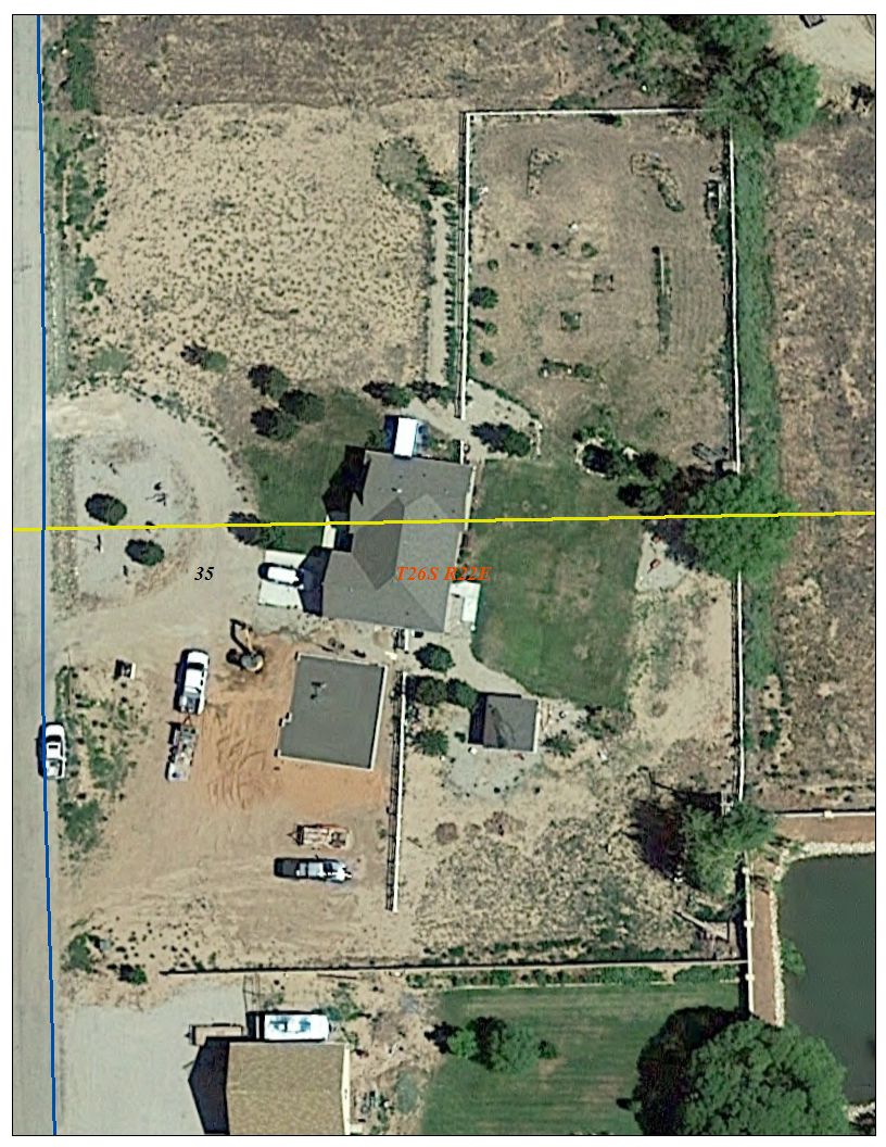
In total, there are 27 property owners affected by the county boundary transecting their land, including private individuals and county, state and federal entities.
Cantrell encouraged Grand County to consider and approve a list of four recommendations and urged them to get written agreements into place.
The recommendations in the report delivered to council are to keep 13 of the county monuments that were located in place; add a monument every 1-mile along the county boundary; provide records of the new survey and re-monumentation to the Utah Lieutenant Governor’s Office and the recorders in each county; and “provide public notice as to the time and location of any public meetings to discuss proposed boundary action.”
The same report was delivered to the San Juan County Commission on Oct. 9. Cantrell said the counties need to come to agreements on jurisdiction issues for law enforcement, EMS, school district and taxation.
“We really need to get away from handshake agreements,” Cantrell said.
Grand County Clerk Diana Carroll told council that at least one registered voter’s home was found to be split by the county boundary line, with the home straddling the line.
“We only have a couple of homes divided by the line,” Fernandez said.
The Grand County Council voted and approved of endorsing and funding $5,802.08 in 2019 for fulfilling the four recommendations contained in Cantrell’s report for the re-monumentation of the Grand and San Juan County boundary.
“We want to make sure there is ample public record by filing this survey plat in both counties.”
Boundary crosses parcels of 27 landowners, including several homes; new markers to be placed


