When it rains, it pours — in early October, at least, the adage rang true for Moab. After months of unusually hot, dry weather, the remnants of Tropical Storm Rosa have brought more than 2 inches of rain to the region, and even more snow to the high elevations in the La Sal Mountains. That’s over 20 percent of the area’s average annual precipitation in just a couple of weeks.
The rain came just in time for the start of a new water year on Oct. 1. The water year is defined as the one-year period beginning on Oct. 1 and ending on Sept. 30. It starts in the fall so that it can accommodate for snow that accumulates in the fall and winter and doesn’t contribute to groundwater until the spring — thus hydrologists prefer this time frame for monitoring groundwater supplies.
Grand County has been at some level of drought since the spring of 2017, according to the United States Drought Monitor, and has been in moderate-to-severe drought since the winter of 2017-18, prompting the Grand County Council to declare a state of drought emergency.
Since that declaration, conditions have deteriorated. As of Sept. 20, Ken’s Lake reservoir was at 15 percent of its 2017 levels.
“Ken’s Lake supplies irrigation water to approximately 168 customers in the valley,” said Dana Van Horn, manager of the Grand Water and Sewer Service Agency (GWSSA). Those customers may be homeowners watering landscapes, or farmers irrigating large areas of crops. Each user pays for a specific allotment of water at the beginning of the year. “Some users have hundreds of acre-feet, while smaller users may only have 1 or 2 (acre-feet).”
Those irrigation rights have been restricted this season, allowing customers to use just 50 percent of their normally allotted water. The irrigation season ended on Oct. 11, and Van Horn said the GWSSA will determine in February 2019 whether restrictions will continue in the spring. At that time, they will be able to consider snowpack from winter precipitation. Runoff from snowmelt in the La Sal Mountains could add a significant amount of water to the reservoir.
Eric Trenbeath is the local forecaster for the Utah Avalanche Center. He reported “an incredible amount of early season snow” in the La Sal Mountains since the first weekend in October, with “about a foot of snow at the Geyser Pass winter trailhead” and some higher elevation areas with over 2 feet of snow.
Some of that precipitation may make its way to the reservoir as runoff before winter truly sets in. But Trenbeath expects a lot of the accumulated snow will remain until the spring.
“Depending on the weather, a little or even a lot of the snow may melt off,” he said, “but the snow on the shady, north-facing slopes is here to stay.”
Trenbeath also noted that the early season snow, while exciting for winter sports enthusiasts, could produce dangerous conditions for backcountry travelers in the mountains.
“This creates a bad scenario for wintertime avalanche conditions,” he said of the accumulation on north-facing slopes. “As the snow that remains on the ground will metamorphose into a weak, sugary layer that will provide an unstable base for future snow loads. This condition can plague the snowpack for much of the season into spring. The only way around this situation is for it to keep on snowing regularly.”
Climate statistics for the year look promising; because the recent rain event coincided so closely with the start of the 2019 water year, current precipitation levels for the year are way above normal. As Van Horn said, “We are off to a good start.”
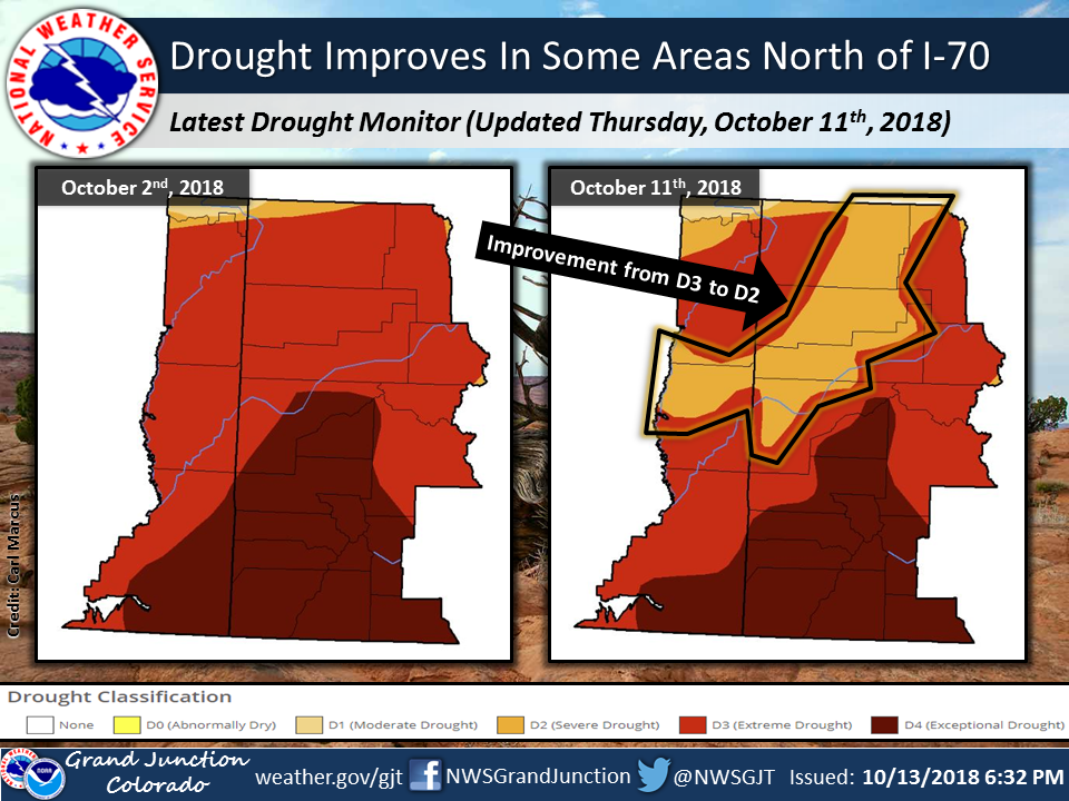
The rain is already having a significant effect. Jim Pringle of the National Oceanographic and Atmospheric Administration in Grand Junction said that the drought status reduced from “extreme,” or D3, to “severe,” or D2, in a large area north of Interstate 70.
“This improvement in the drought status was due to the extensive precipitation which occurred so far as of Oct. 11,” Pringle said.
However, that higher-than-average precipitation will have to continue for the region to fully recover from drought. Fortunately, there is a chance that will happen. Pringle said the Climate Prediction Center “indicates an encouraging situation for our region,” with an “expected weak-to-moderate El Niño episode” bringing more moisture throughout the winter. Three-month outlook maps include southeastern Utah in a swath of green through the winter and early spring, representing a 40-percent chance of receiving above-average precipitation.
This is good news for winter athletes and recreationists. Mountain travel will be less risky with a lot of snowfall. As Trenbeath said, “A deep snowpack is a strong snowpack.”
It’s of course also good news for irrigators. Van Horn was cautiously optimistic.
“It has been my experience that it takes a few years to get over such a devastating season,” she said, adding, “We will be prepared for whatever the weather brings — and hopefully that is a ton of snow!”
Intense recent rains good news for irrigators, but Grand County remains in ‘extreme’ and ‘severe’ drought
“We are off to a good start.”


