The La Sal Mountains haven’t been pummeled by the kinds of storms that hit the area this time last year, when even the city of Moab was blanketed under a layer of snow.
But avalanche conditions are still developing in the higher elevations of the range, according to local Utah Avalanche Center forecaster Eric Trenbeath.
“Right now, we’ve got a shallow snowpack, with not many storms lined up, so what snow is on the ground is getting weaker and weaker,” he said Dec. 4.
There is currently about 10 inches of snow on the ground at the Geyser Pass trailhead, and around 20 inches in the trees and bowls of the higher-elevation Gold Basin.
Friends of the Utah Avalanche Center volunteer Mark Sevenoff hasn’t ventured up into the high La Sals yet this week, but he believes that conditions for recreationists are far from ideal.
“Right now, I would be hard-pressed to call it anything more than marginal,” Sevenoff said.
Trenbeath agrees that current conditions aren’t optimal for skiing or snowmobiling off the Geyser Pass Road.
“We need one or two significant storms before it’s really game on up there,” he said.
This might be a good time, then, for backcountry visitors to commit the avalanche center’s “know before you go” motto to memory, if they haven’t done so already.
Trenbeath suggests that they should also get in the habit of checking out the avalanche center’s local forecasts at http://utahavalanchecenter.org/advisory/moab. Site visitors can find ratings based on current conditions, as well as field tests and observations.
“We hope that people will use the advisory to make good decisions about where they choose to recreate in the mountains on a given day,” he said.
The advisory program is a collaborative effort between the U.S. Forest Service and the nonprofit Friends of the Utah Avalanche Center.
Trenbeath returns to the job for the second year in a row with two decades of experience behind him. In the 1990s, he worked as a ski patroler at Alta Ski Area, and more recently, he served with the local avalanche center between 1999 and 2003.
In addition to his work on forecasts for the La Sal and Abajo Mountains, he’s there to clear up common misconceptions about avalanches – such as the still-widespread belief that avalanches occur by chance.
“Ninety-five percent of avalanche victims trigger the avalanche themselves,” he said.
To reduce that risk, Trenbeath suggests that backcountry recreationists can look for obvious signs of instability – such as cracking and collapsing snow surfaces or recent avalanches – when they’re up in the mountains.
Avalanche forecasting is technical, but Trenbeath can boil the risk of triggering an event down to a combination of three factors: terrain, weather and snowpack structure.
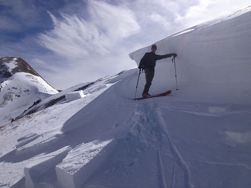
Sharp slopes of 35 degrees or more – which are about as steep as an expert-level ski area run – are common in the La Sals, and backcountry recreationists have to be careful in those areas.
“It’s a highly avalanche-prone mountain range because it is so steep,” Trenbeath said.
The direction that a slope faces in relation to the wind and the sun can also determine how dangerous conditions are, he said.
Wind, in particular, is the biggest factor in causing avalanche conditions, he said: Gusts will pick up snow from one place and then deposit it somewhere else.
“Snow falling straight down out of the sky in nice, fluffy powder as it piles up, does not create avalanche conditions,” he said. “It’s slab avalanches that we’re worried about, and slab avalanches are really a big wind drift of snow.”
Rapid warming is another factor, and finally, there’s snow structure. Each subsequent storm that passes through the area, along with every sun and wind event, changes the snow’s surface or layers, he said: Some layers may be weak, and cannot handle the additional weight of a snowmobiler or skier.
“The biggest thing is stress overriding strength of the snowpack: That’s what causes an avalanche,” Trenbeath said. “You’ve got very weak layers underneath, and then you get a big load on top, and then it fails.”
Sevenoff said that some lower-angle areas in the La Sals, such as Laurel Meadows, pose fewer risks to skiers, snowboarders and snowmobilers.
Even if current conditions there aren’t as good as they were last year, Sevenoff encourages people to shake off the cobwebs and practice their equipment in those areas. That way, he said, they can be ready if and when the big storm arrives.
But as they set off on their trips, he suggests that they should heed a quote he heard years ago: “The avalanche doesn’t care if you’re an expert, so no matter how much experience you have, be humble.”
“It’s better to be cautious and live to see another day, whether you’re a snowmobiler, a skier or a snowboarder,” he added.
It also pays to follow other precautions that could reduce travel-related risks on the roads, he said.
Sevenoff said he routinely spots traffic accidents along the drive up the La Sal Mountain Loop Road, which he attributes to a lack of planning or preparation ahead of time.
“I’ve seen a lot of first-timers get skunked before they even make it to the parking lot, because they don’t even have chains or a four-wheel drive,” Sevenoff said.
For more information about the Utah Avalanche Center’s Know Before You Go program, go to: http://utahavalanchecenter.org/know-before-you-go.
Despite limited early season snowpack, danger still exists from slides
“We hope that people will use the advisory to make good decisions about where they choose to recreate in the mountains on a given day.”


